
A strong storm system is moving in, bringing heavy rain, snow for some, and areas of gusty winds(mostly on Monday).Before the rain moved in, temperatures got warmer in many parts of New Hampshire, with highs in the upper 50s from Manchester south and east on Sunday. It turned even warmer from Manchester south and east Sunday Evening(60 to 64 degrees!) as some heavy rain moved through.>> Interactive Radar | Traffic trackerRain will fall at varying intensities(heavy at times) overnight. That rain has changed to wet snow in far northern New Hampshire and that rain/snow line will work a bit farther south overnight into early Monday. In western parts of central and southern New Hampshire, the rain will change to wet snow during the Monday AM commute.It will be quite breezy, mainly at the coast overnight, with the potential for gusts over 30-35 mph. There is a chance of a few scattered power outages, mainly along the coast overnight, but the strongest winds will stay off to our southeast.>> National Weather Service alerts and bulletins By Monday, gusty west/northwest winds will kick in statewide (from late morning into the afternoon), resulting in scattered outages. Those winds will peak at 30-40 mph.The rain will be heavy at times, with 1-3 inches statewide. A few isolated higher amounts are possible. >> Hour-by-hour timelineA flood watch is in effect through Monday evening for all of New Hampshire, except for Coos County. Some flooding is possible up north due to heavy rain and melting snow with road ponding possible anywhere in the state. Small rivers and streams will begin to swell overnight into Monday with minor flooding in spots. Larger rivers will continue to swell into Monday and Tuesday. Some low-lying areas could experience minor flooding. Street flooding is likely in some areas during the overnight and morning commute hours on Monday.The snow in northern and northwestern parts of the state will accumulate several inches with up to 10″ in parts of far northern New Hampshire by midday on Monday. The precipitation will quickly end by late morning south and early afternoon on Monday farther north, as those gusty winds out of the west/northwest continue. The winds will weaken Monday night.A winter storm warning will be in effect 1 a.m. to 7 p.m. Monday for northern Coos County.Roads will be slippery in northern and far western New Hampshire for the morning commute on Monday with road ponding a concern elsewhere.Be weather aware! Download the WMUR app for Apple or Android devices and turn on push notifications. You can choose to receive weather alerts for your geolocation and/or up to three ZIP codes. In addition, you can receive word when precipitation is coming to your area.Follow the Storm Watch 9 team on social media:Mike Haddad: Facebook | XKevin Skarupa: Facebook | XHayley LaPoint: Facebook | XJacqueline Thomas: Facebook | XMatt Hoenig: Facebook | X
A strong storm system is moving in, bringing heavy rain, snow for some, and areas of gusty winds(mostly on Monday).
Before the rain moved in, temperatures got warmer in many parts of New Hampshire, with highs in the upper 50s from Manchester south and east on Sunday. It turned even warmer from Manchester south and east Sunday Evening(60 to 64 degrees!) as some heavy rain moved through.
>> Interactive Radar | Traffic tracker
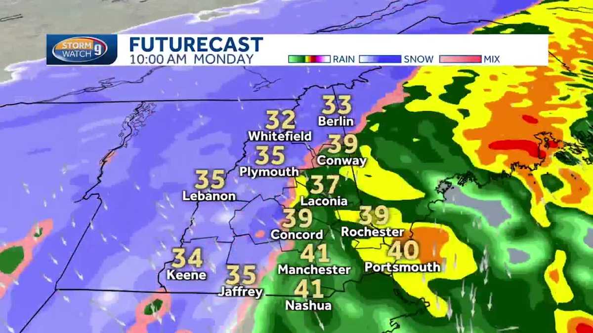
Rain will fall at varying intensities(heavy at times) overnight. That rain has changed to wet snow in far northern New Hampshire and that rain/snow line will work a bit farther south overnight into early Monday. In western parts of central and southern New Hampshire, the rain will change to wet snow during the Monday AM commute.
It will be quite breezy, mainly at the coast overnight, with the potential for gusts over 30-35 mph. There is a chance of a few scattered power outages, mainly along the coast overnight, but the strongest winds will stay off to our southeast.
>> National Weather Service alerts and bulletins
By Monday, gusty west/northwest winds will kick in statewide (from late morning into the afternoon), resulting in scattered outages. Those winds will peak at 30-40 mph.
The rain will be heavy at times, with 1-3 inches statewide. A few isolated higher amounts are possible.
>> Hour-by-hour timeline
A flood watch is in effect through Monday evening for all of New Hampshire, except for Coos County. Some flooding is possible up north due to heavy rain and melting snow with road ponding possible anywhere in the state.
Small rivers and streams will begin to swell overnight into Monday with minor flooding in spots. Larger rivers will continue to swell into Monday and Tuesday. Some low-lying areas could experience minor flooding. Street flooding is likely in some areas during the overnight and morning commute hours on Monday.
The snow in northern and northwestern parts of the state will accumulate several inches with up to 10″ in parts of far northern New Hampshire by midday on Monday.
The precipitation will quickly end by late morning south and early afternoon on Monday farther north, as those gusty winds out of the west/northwest continue. The winds will weaken Monday night.
A winter storm warning will be in effect 1 a.m. to 7 p.m. Monday for northern Coos County.
Roads will be slippery in northern and far western New Hampshire for the morning commute on Monday with road ponding a concern elsewhere.
Be weather aware! Download the WMUR app for Apple or Android devices and turn on push notifications. You can choose to receive weather alerts for your geolocation and/or up to three ZIP codes. In addition, you can receive word when precipitation is coming to your area.
Follow the Storm Watch 9 team on social media: