
Hurricane Lee strengthened rapidly Thursday and developed into a major Category 5 storm, the National Hurricane Center said.
Lee intensified quickly over the Atlantic Ocean’s very warm waters, growing from a tropical storm into a Category 1 hurricane on Wednesday and all the way to a Category 5 hurricane Thursday night, with maximum sustained winds of 160 mph.
Lee was forecast to continue intensifying Friday and despite possible fluctuations in intensity, it was expected to “remain a major hurricane through early next week,” the center said.
“Even as we head into Saturday, Sunday, Monday and Tuesday it does weaken, (and) that’s good news as it heads towards the U.S.,” CBS News senior weather and climate producer David Parkinson said Thursday evening.
NOAA/GOES Satellite image
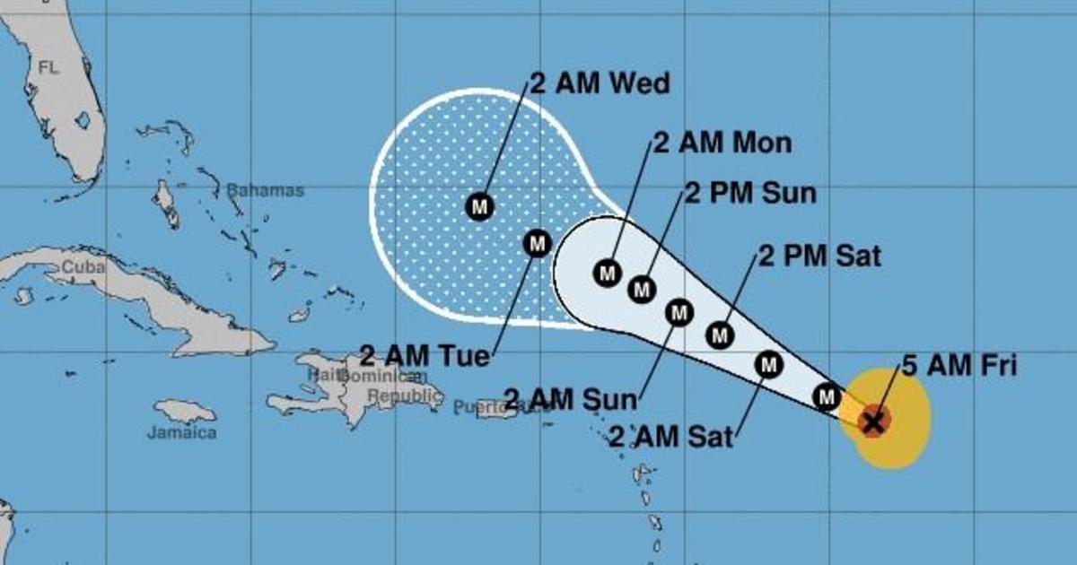
Where is Hurricane Lee heading?
Large ocean swells generated by Lee are expected to reach the Lesser Antilles by Friday, and the U.S. and British Virgin Islands, Puerto Rico, the Bahamas, Bermuda, the Turks and Caicos Islands and Hispaniola by the weekend, the hurricane center said.
As of 5 a.m. EDT on Friday, Lee had maximum sustained winds of 165 mph. Its center was about 630 miles east of the northern Leeward Islands and it was traveling west-northest at 14 mph over the Atlantic.
The Leewards are a group of islands where the Caribbean Sea meets the western Atlantic Ocean.
National Hurricane Center
Large ocean swells generated by Lee are expected to reach the Lesser Antilles by Friday, and the U.S. and British Virgin Islands, Puerto Rico, the Bahamas, Bermuda, the Turks and Caicos Islands and Hispaniola by the weekend, the hurricane center said.
“These swells are likely to cause life-threatening surf and rip current conditions,” the agency reported.
However, Lee’s center is forecast to pass “well to the north” of those islands, the agency added.
There are no coastal warnings or watches in effect at this time, the hurricane center said.
Where will Hurricane Lee make landfall?
Right now, it’s too early to say whether Hurricane Lee will make landfall, forecasters said.
Parkinson laid out a few possible scenarios for Lee. One would involve a cold front coming off the East Coast that could trap Lee and push it north against the coastline, bringing potentially stormy weather to areas along the coast.
However, if no cold front forms, Parkinson explained, Lee would then potentially stay out at sea for a longer period until reaching Newfoundland and Labrador in Canada. By that point, it may have significantly weakened.
This is one of the most impressive rapid intensification episodes I’ve ever seen in the Atlantic. Hurricane #Lee went from having no eye this morning to possibly Cat 5 intensity this evening. Absolutely incredible. pic.twitter.com/49NmtkIJO2
— Dr. Levi Cowan (@TropicalTidbits) September 8, 2023
Is Hurricane Lee going to hit Florida?
Hurricane Lee is not currently forecast to impact Florida, CBS Miami reported. CBS Miami chief meteorologist and hurricane specialist Ivan Cabrera Lee said the storm system is expected to turn to the north and away from the southeastern U.S. coast, but weather experts will continue to monitor its progress and track it closely.
Florida is recovering from Hurricane Idalia, which made landfall along the Gulf Coast last Wednesday and left a trail of damage across the Big Bend region — the area where the Florida peninsula meets the panhandle. The storm caused severe flooding in Florida and other states including Georgia, South Carolina and North Carolina, before moving out to sea. Several deaths have been attributed to the storm, and the financial toll of the hurricane could reach $20 billion, CBS News previously reported.
Hurricane Lee spaghetti models
Spaghetti weather models, or spaghetti plots, are computer models showing the possible paths a storm may take as it develops. These models don’t predict the impact or when a storm may hit, according to the Weather Channel, but focus on showing which areas might potentially be at risk.
Spaghetti models for Hurricane Lee mostly show the storm traveling over the ocean. Some paths would take the storm close to the Leeward Islands, which include the Virgin Islands, Anguilla, Saint Martin and Saint Kitts.
A spaghetti model for Lee created Wednesday morning, seen below, shows most projected paths curving northward and remaining out over the open Atlantic, but a few veer more to the west for a potential impact in the islands or along the U.S. Mid-Atlantic or New England coast late next week.
National Center for Atmospheric Research/University Corporation for Atmospheric Research
Another set was posted by The Weather Channel’s Jim Cantore, who wrote: “Some solutions into late next week (shown below) are too close to ignore. Some don’t touch land. This is all common with something in the 7-10 day away range.”
Model ensemble blend look at #Lee next week. Some solutions into late next week (shown below) are too close to ignore. Some don’t touch land. This is all common with something in the 7-10 day away range. Plus the simple fact that track errors go up rapidly after 5 days which… pic.twitter.com/KCbIHRnU2D
— Jim Cantore (@JimCantore) September 7, 2023