
NEW YORK – On the heels of last winter, a.k.a. “the winter that wasn’t,” snow lovers had high hopes for this winter being the one to break the pattern of low snowfall.
CBS2
To their dismay, this winter has not delivered, with only 2.3 inches of snow recorded thus far. That matches the snowfall received for all of last winter.
Mild temperatures have been prevalent once again this winter, and that has led to more rain falling than snow.
CBS2
Every day of this month has featured above-average readings, with the warmth expected to last through the weekend.
CBS2
Record highs may even be achieved on Saturday.
CBS2
Given such a mild pattern, the thought of a snowstorm seems highly unlikely. However, the odds are increasing that one is in the cards as we head into next week.
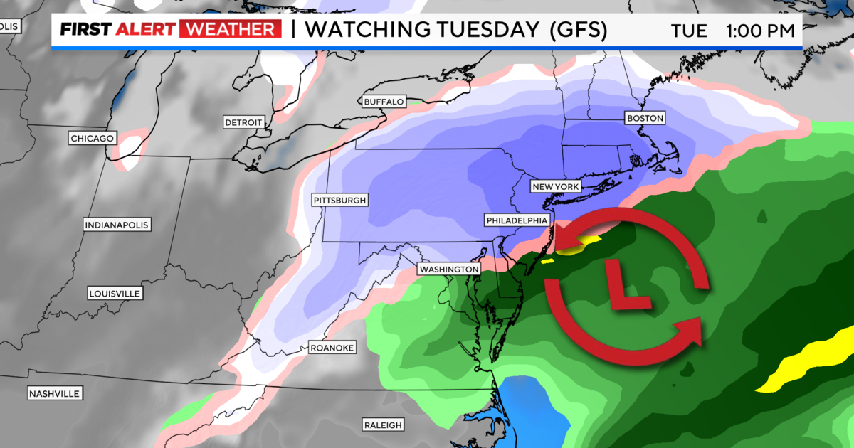
By early next week, a dip in the jet stream will allow colder air to filter into the region, making the spring-like temperatures just a memory. With colder air in place, snow is definitely on the table as a storm system works its way through the region late Monday into Tuesday.
Initially, precipitation will begin as rain, however, as the storm deepens, it will be able to draw colder air into it, and therefore, rain will change over to snow.
CBS2
Unlike other storms this winter, the forecast models this time are generally on the same page, with no huge disparities in snow totals. When forecasting snowfall, seeing an agreement among the models is very promising.
CBS2
As of Friday afternoon, plowable snow is likely, even for coastal areas. The American model is the most aggressive, depicting around 6.5 inches of snow in Central Park, and up to 1 foot for our northwestern suburbs.
CBS2
On the other hand, its European counterpart is a little less bullish, but also shows predicts a decent snowfall, with around 5 inches in the city, and closer to 9 inches north and west.
CBS2
Either way, whatever amount of snow that falls will be heavy and wet. This type of snow, frequently referred to as “heart attack snow,” can be particularly dangerous to individuals with underlying health conditions, so caution will be needed for those in that group who choose to shovel. That heavy, wet snow, coupled with winds that could gust up to 40 mph, may lead to power outages. Moderate coastal will also be a concern with this storm, especially on Tuesday morning.
Typically, February is the snowiest month of the year, yet we haven’t recorded any snow so far this February.
In fact, most of the local cities and towns are running double digit deficits for the season. In an average February, around 10 inches of snow falls.
February is also the month that has featured some of greatest snowstorms, including the President’s Day storm of 2003 that dumped over 20 inches of snow on the region. It’s also the month that holds the record for snowiest month ever recorded. That was February 2010, when 36.9 inches fell.
CBS2
Getting snow to fall and accumulate has proven to be extremely difficult in the last several years. Even more difficult has been getting a snowfall over 2 inches. The last time that occurred was on Jan. 29, 2022. Could this storm finally be the one that changes this pattern? Climatology says yes, and so do our forecast models.
The bigger question is will Mother Nature cooperate this time?
What to expect by region Monday into Tuesday
CBS New York
Jersey Shore and Central New Jersey:
Rain to start, changing to all snow eventually. Final totals: .75-1 inch of rain, 1-3 inches of snow. Wind gusts up to 40 mph. Moderate coastal flooding and high surf may lead to beach erosion.
Long Island:
Rain or mixed precipitation to start, changing to a mix of rain and snow, then changing to all snow. Final totals: .5-1 inch of rain, 3-7 inches of snow. Wind gusts up to 40 mph. Moderate coastal flooding and high surf may lead to beach erosion.
CBS New York
NYC:
Rain to start, then a rain/snow mix, then changing to all snow. Final totals: .5-1 inch of rain, 3-6 inches of snow. Wind gusts up to 35 mph.
Hudson Valley, Northern New Jersey:
This is where the highest snow totals are expected. Here, less mixing with rain is anticipated, although there will be rain to start. Snowfall totals, averaging between 6-10 inches, with certain spots possibly reaching up to a foot or more. Wind gusts up to 35 mph.
CBS New York
Coastal Connecticut:
Rain to start, changing to a wintry mix, then all snow. 4-7 inches of snow is likely. Wind gusts up to 40 mph, with some moderate coastal flooding.