
Kansas City was spared of severe weather on Friday, but counties north of Kansas City experienced severe storms. Multiple tornado warnings were issued for northern counties in KMBC’s viewing area. The National Weather Service confirmed at least one tornado. Storm damage was also reported in Ray County, Missouri. Live updates: 9:30 p.m. — KMBC’s Brian Johnson was on the scene of storm damage in Ray County, Missouri on Friday night. No injuries were reported, but there were homes damaged. 7:26 p.m. — Evergy is reporting a little over 170 customers are without power near Alma, Missouri. 7:22 p.m. — The National Weather Service says there was a confirmed tornado located over Malta Bend, Missouri, which is located nine miles northwest of Marshall, Missouri. The storm is moving east at 35 miles per hour. There’s no extensive damage at this time. 7:14 p.m. — A new tornado warning has been issued for Carroll and Saline County in Missouri. Warning is in place until 7:45 p.m.6:44 p.m. — A tornado warning has been issued for Carroll and Livingston County, Missouri. 6:43 p.m. — The Ray County Sheriff’s Office said a tornado touched down in Hardin, Missouri. It went across 10 Highway. A home was damaged north of Hardin off of A Highway. There are no reported injuries. KMBC’s Nick Bender was tracking the storm: 6:27 p.m. — A tornado warning was issued for Ray County shortly after 6 p.m., but it was allowed to expire. 5:18 p.m. — A severe thunderstorm watch has been issued for counties on the Missouri side, including: Caldwell, Carroll, Cass, Clay, Clinton, Grundy, Henry, Jackson, Johnson, Lafayette, Linn, Livingston, Pettis, Ray and Saline County. Kansas City, Missouri is included in the watch. No counties on the Kansas side of the KMBC viewing area are included. Damaging wind and hail are the main risks, but the threat for tornadoes cannot be ruled out. The watch is in place until 11 p.m.The forecast: A mesoscale convective vortex denoted by the big, red “L” in north-central Kansas continued to track east into northern Missouri through this morning. As the MCV approaches Kansas City and central Missouri this afternoon, it will encounter larger amounts of surface instability. This combined with enhanced convergence and lift associated with the MCV could give way to a small cluster of strong to severe thunderstorms. Storms are most likely to develop between 3 p.m. and 8 p.m. for areas stretching from Kansas City east into central Missouri. Damaging wind, large hail and a brief tornado will be possible.First Alert Meteorologist Katie Horner said part of the Kansas City area is now under what is considered an increased tornado risk for this time frame. First Alert Chief Meteorologist Bryan Busby said the slow-moving storm system has the potential to produce all forms of strong to severe weather, with damaging wind, large hail, and a possible tornado as the main threats. Make sure you have multiple ways of receiving watches and warnings as we get closer to this severe weather event. The KMBC 9 News app has the ability to send weather alerts. Heavy rain and a few storms are possible overnight into Saturday.Another chance for leftover storms are possible Saturday evening into Sunday before we get a break with cooler temperatures.
Kansas City was spared of severe weather on Friday, but counties north of Kansas City experienced severe storms.
Multiple tornado warnings were issued for northern counties in KMBC’s viewing area.
The National Weather Service confirmed at least one tornado. Storm damage was also reported in Ray County, Missouri.
Live updates:
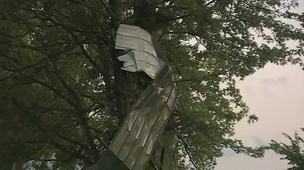
9:30 p.m. — KMBC’s Brian Johnson was on the scene of storm damage in Ray County, Missouri on Friday night. No injuries were reported, but there were homes damaged.
7:26 p.m. — Evergy is reporting a little over 170 customers are without power near Alma, Missouri.
7:22 p.m. — The National Weather Service says there was a confirmed tornado located over Malta Bend, Missouri, which is located nine miles northwest of Marshall, Missouri.
The storm is moving east at 35 miles per hour.
There’s no extensive damage at this time.
7:14 p.m. — A new tornado warning has been issued for Carroll and Saline County in Missouri. Warning is in place until 7:45 p.m.
6:44 p.m. — A tornado warning has been issued for Carroll and Livingston County, Missouri.
6:43 p.m. — The Ray County Sheriff’s Office said a tornado touched down in Hardin, Missouri. It went across 10 Highway.
A home was damaged north of Hardin off of A Highway.
There are no reported injuries.
KMBC’s Nick Bender was tracking the storm:
6:27 p.m. — A tornado warning was issued for Ray County shortly after 6 p.m., but it was allowed to expire.
5:18 p.m. — A severe thunderstorm watch has been issued for counties on the Missouri side, including: Caldwell, Carroll, Cass, Clay, Clinton, Grundy, Henry, Jackson, Johnson, Lafayette, Linn, Livingston, Pettis, Ray and Saline County.
Kansas City, Missouri is included in the watch.
No counties on the Kansas side of the KMBC viewing area are included.
Damaging wind and hail are the main risks, but the threat for tornadoes cannot be ruled out.
The watch is in place until 11 p.m.
The forecast:
A mesoscale convective vortex denoted by the big, red “L” in north-central Kansas continued to track east into northern Missouri through this morning. As the MCV approaches Kansas City and central Missouri this afternoon, it will encounter larger amounts of surface instability. This combined with enhanced convergence and lift associated with the MCV could give way to a small cluster of strong to severe thunderstorms.
[Click here to track radar]
Storms are most likely to develop between 3 p.m. and 8 p.m. for areas stretching from Kansas City east into central Missouri. Damaging wind, large hail and a brief tornado will be possible.
First Alert Meteorologist Katie Horner said part of the Kansas City area is now under what is considered an increased tornado risk for this time frame.
First Alert Chief Meteorologist Bryan Busby said the slow-moving storm system has the potential to produce all forms of strong to severe weather, with damaging wind, large hail, and a possible tornado as the main threats.
Make sure you have multiple ways of receiving watches and warnings as we get closer to this severe weather event. The KMBC 9 News app has the ability to send weather alerts.
[Download the app | Sign up for custom weather alerts]
Heavy rain and a few storms are possible overnight into Saturday.
Another chance for leftover storms are possible Saturday evening into Sunday before we get a break with cooler temperatures.