
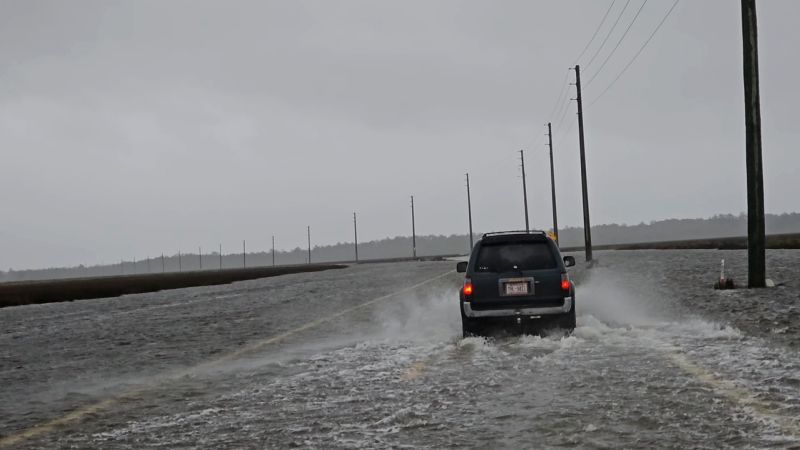
Bryce Shelton/LSM
A driver navigates a flooded highway in Cedar Island, North Carolina, on Friday, September, 22, as Tropical Storm Ophelia approached the state.
CNN
—
[Breaking news update published at 6:25 a.m. ET]
Ophelia made landfall near Emerald Isle, North Carolina, on Saturday morning as a strong tropical storm, which already has knocked out power to tens of thousands with its strong winds as its rain and storm surge flooding reach areas of the East Coast well beyond the storm’s center.
[Previous story, published at 5:12 a.m. ET]
Tropical Storm Ophelia is delivering strong winds, rain and storm surge flooding early Saturday to the coasts of North Carolina and Virginia, where communities are now experiencing power outages.
The storm is expected to bring heavy rain across a large swath of the mid-Atlantic, including Maryland, Delaware, New Jersey and New York, beginning Saturday morning and continuing through the weekend.
But coastal areas in North Carolina are expected to bear the brunt of impacts as the expansive storm is poised to make landfall early Saturday, the National Hurricane Center said.
Centered about 25 miles southwest of Cape Lookout, North Carolina, Ophelia’s maximum sustained winds were near 70 mph, the hurricane center said Saturday at 5 a.m. ET. The storm was moving at about 9 mph, and it is expected to trek north along the East Coast over the weekend as it weakens after landfall.
Roughly 52,000 homes and businesses across North Carolina and Virginia had lost power by early Saturday, according to utility tracking site PowerOutage.us.
Some places in eastern North Carolina and southeast Virginia could see between 3 and 5 inches of rain, with others seeing up to 7 inches, through Sunday morning.
“The combination of a dangerous storm surge and the tide will cause normally dry areas near the coast to be flooded by rising waters moving inland from the shoreline,” the hurricane center warned.
TRACK THE STORM
Key threats:
• Hurricane watch: Areas north of Surf City, North Carolina, to Ocracoke Inlet are under a hurricane watch. The state also is under an emergency declaration.
• Storm surge threat: Storm surge watches and warnings are in effect from Surf City, North Carolina, to the Chesapeake Bay. A storm surge happens when strong winds cause water levels to rise and push water on-shore. Water levels began rising Friday night along some coastal areas in North Carolina.
• Dangerous flooding: The risk of flash flooding during overnight hours has increased for eastern North Carolina, according to the state’s emergency management department. Storm surge is forecast along the Pamlico and Neuse rivers, the department warned.
• Rainfall: Other states in the Mid-Atlantic could pick up 2 to 4 inches on rain Saturday night through Sunday. Meanwhile, 1 to 3 inches of rain are forecast across southern New York through southern New England beginning Saturday into Monday.
View this interactive content on CNN.com
On Friday, communities along North Carolina’s coast had already begun seeing flooded roads. In coastal Cedar Island, water collected on Highway 12, though it was open and passable, the state transportation department said.
“But please don’t go out tonight unless you absolutely have to. There is sand and water on the roadway, and it’s dark and stormy,” the department said in a social media post.
In New Bern, which sits along two rivers in North Carolina about 120 miles east of Raleigh, roads were flooded and water creeped inland as the levels rose in the downtown area, city officials said on Facebook. Photos posted on the city’s page show a flooded children’s park and ducks floating down the street on floodwaters.
Ophelia is on track to move across eastern North Carolina and then travel through southeastern Virginia, before heading further north across the Delmarva Peninsula Saturday and Sunday, the hurricane center said.
Kendall Warner/The Virginian-Pilot/AP
Waves break along the jetty at Rudee Inlet in Virginia Beach, Va., on Friday, Sept. 22, 2023 as Tropical Storm Ophelia approaches the area.
Tropical-storm-force winds – between 39 and 73 mph – extend outward up to 300 miles from the Ophelia’s center, according to the hurricane center. A few tornadoes also are possible in parts of the coastal mid-Atlantic.
In Maryland, the governor declared an emergency due to the storm’s potential impacts.
“If you can avoid driving or being out during the storm please do so. We are expecting an extended period of strong winds, heavy rainfall, and elevated tides,” Maryland Gov. Wes Moore said.
As the storm threatens to bombard coastal areas with the worst of the winds and rain, some inland communities in southern New England will still see impacts.
“Heavy rainfall from this system could produce locally considerable flash, and urban flooding impacts across portions of the Mid-Atlantic states from North Carolina to New Jersey through Sunday,” the hurricane center said.
The storm could also bring dangerous surf and rip currents along East Coast through the weekend, the hurricane center warned.
One to 5 feet of surge is possible in some areas, particularly in inlets and rivers from around Surf City, North Carolina, to Manasquan Inlet on the New Jersey shore.