
<NATURAL SOUND> HEADING INTO THE EVENING HOURS ONCE THE WARM FRONT MOVES OVER THE CENTRAL COAST AND THE COLD FRONT NEARS THE COAST, IT IS EXPECTED THAT RAINFALL RATES WILL FURTHER INCREASE, ESPECIALLY FOR OROGRAPHICALLY ENHANCED AREAS FROM THE SANTA CRUZ MTNS SOUTHWARD. AREAS OF 0.5-0.6 INCHES PER HOUR APPEAR LIKELY ALONG THE BIG SUR COAST, SANTA LUCIA, AND SANTA CRUZ MTNS LATE THIS EVENING, PERSISTING FOR A LONGER PERIOD OVER THE SANTA LUCIA, WHERE RAINFALL RATES COULD APPROACH UP TO 1 INCH PER HOUR IN ISOLATED AREAS. THIS HAS PROMPTED THE ISSUANCE OF A FLASH FLOOD WATCH FOR THE RIVER FIRE BURN SCAR FOR THE POSSIBILITY OF DEBRIS FLOWS, MUDSLIDES, AND FLASH FLOODING IN THE BURN SCAR AREA AND LOW-LYING AREAS ALONG THE CARMEL RIVER NEAR THE BURN SCAR. AS WE MOVE INTO THE OVERNIGHT PERIOD, FURTHER DESTABILIZATION OCCURS WITH ADDITIONAL COOLING ALOFT CREATING A MORE FAVORABLE ENVIRONMENT FOR THUNDERSTORMS. AT THE MOMENT, IT APPEARS THAT THE INITIAL THREAT WILL BE FOR AREAS MORE NEAR THE COAST AND THE NORTH BAY DURING THE OVERNIGHT PERIOD. A WIDESPREAD BREAK IN THE RAINFALL APPEARS LIKELY MONDAY MORNING AS THE INITIAL WAVE PUSHES THROUGH FURTHER EAST INTO THE STATE. THIS OPENS THE DOOR FOR THE SECOND WAVE OF RAINFALL LATER MONDAY MORNING WHERE A GREATER LIKELIHOOD FOR THUNDERSTORMS EXISTS OVER A LARGER AREA. CURRENT THUNDERSTORM- RELATED THREATS INCLUDE GUSTY WINDS AND LIGHTNING, AND A SLIGHT THREAT FOR WATERSPOUTS ALONG THE COAST. HIGH RES GUIDANCE HAS BEEN RELATIVELY CONSISTENT AT DEPICTING A LINE OF HEAVIER SHOWERS AND THUNDERSTORMS TRAINING INTO THE BAY AREA MONDAY AFTERNOON. SHOULD THIS BE THE CASE, WE COULD END UP WITH ISOLATED LOCATIONS ALONG THE PENINSULA AND EAST BAY THAT END UP WITH A BIT MORE RAINFALL THAN EXPECTED. HOWEVER, THESE SUCH FEATURES ARE NOTORIOUSLY DIFFICULT TO NAIL DOWN, SO WILL KEEP THAT IN THE BACK POCKET AS A LOW
Impact Day: Evacuation warnings issued in Monterey County, shelters opened in Santa Cruz County
Just two weeks removed from storms that knocked power to hundreds of thousands of homes on the Central Coast and throughout California, the Golden State expects another batch of storms Sunday evening.

Updated: 10:15 PM PST Feb 18, 2024
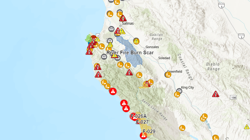
Just two weeks removed from storms that knocked power to hundreds of thousands of PG&E customers on the Central Coast and throughout California, the Golden State is expecting another batch of storms Sunday evening. Evacuation Warnings Low-lying areas of Carmel River (until further notice)Areas downslope River Fire burn scar:Berry Drive Pine Canyon Road 800 block River RoadLimekiln RoadParker Road The National Weather Service also issued a flash flood watch for people in the River Fire burn scar area.Rain is expected to arrive Sunday afternoon and during the evening into Monday, the system is expected to be at its strongest. Fifteen to 30 mph winds are expected to linger on the Central Coat until Tuesday morning. Power Outages There are currently 158 people without power in Santa Cruz County and 296 people without power in Monterey County, according to PG&E.To get the latest information on the power outages, follow on the PG&E Outage Center. Road Closures Monterey County:Murphy Road crossing in north Monterey County.Planned road closures for Sunday or Monday (currently open) low-level crossings over the Salinas River. Elm Street east of Greenfield and Davis Road south of Salinas. To keep up with the latest evacuations on the Central Coast, click here.Severe Weather Shelters Santa Cruz County: Vets Hall at 846 Front Street, Santa Cruz. From 8 p.m. to 8 a.m. on Feb. 18 and Feb. 19. Then on Feb. 20 from 10 p.m. to 7 a.m. Depot Park at 119 Center Street, Santa Cruz opens at noon on Feb 18. and will close at noon on Feb. 21. Vets Hall at 215 Beach Street, Watsonville opens at noon on Feb. 18 and closes at noon on Feb. 21. KSBW has compiled helpful guides to prepare you for the upcoming weather event.Related | What to keep and what to toss out your fridge following a power outageWeather Evacuations | How to prepare and what to bring
Just two weeks removed from storms that knocked power to hundreds of thousands of PG&E customers on the Central Coast and throughout California, the Golden State is expecting another batch of storms Sunday evening.
Evacuation Warnings
- Low-lying areas of Carmel River (until further notice)
- Areas downslope River Fire burn scar:
- Berry Drive
- Pine Canyon Road
- 800 block River Road
- Limekiln Road
- Parker Road
The National Weather Service also issued a flash flood watch for people in the River Fire burn scar area.
Rain is expected to arrive Sunday afternoon and during the evening into Monday, the system is expected to be at its strongest. Fifteen to 30 mph winds are expected to linger on the Central Coat until Tuesday morning.
Power Outages
There are currently 158 people without power in Santa Cruz County and 296 people without power in Monterey County, according to PG&E.
To get the latest information on the power outages, follow on the PG&E Outage Center.
Road Closures
Monterey County:
- Murphy Road crossing in north Monterey County.
- Planned road closures for Sunday or Monday (currently open) low-level crossings over the Salinas River. Elm Street east of Greenfield and Davis Road south of Salinas.
To keep up with the latest evacuations on the Central Coast, click here.
Severe Weather Shelters
Santa Cruz County:
- Vets Hall at 846 Front Street, Santa Cruz. From 8 p.m. to 8 a.m. on Feb. 18 and Feb. 19. Then on Feb. 20 from 10 p.m. to 7 a.m.
- Depot Park at 119 Center Street, Santa Cruz opens at noon on Feb 18. and will close at noon on Feb. 21.
- Vets Hall at 215 Beach Street, Watsonville opens at noon on Feb. 18 and closes at noon on Feb. 21.
KSBW has compiled helpful guides to prepare you for the upcoming weather event.
Related | What to keep and what to toss out your fridge following a power outage
Weather Evacuations | How to prepare and what to bring