
CNN
—
Concern is growing Hurricane Hilary will unleash a prolific amount of flooding rainfall on the southwestern US and parts of California as it makes a rare move over the region Sunday and into early next week, triggering a tropical storm warning for parts of Southern California.
Hilary could dump more than a year’s worth of rain in parts of three states: California, Nevada and Arizona. Because of the threat, parts of California face a rare high risk for excessive rainfall. This Level 4 of 4 threat is the first to ever be issued for this part of Southern California.
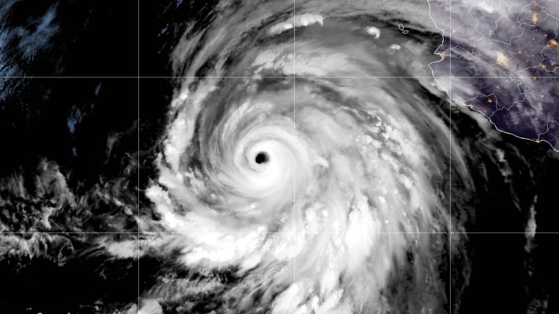
Hilary was a powerful Category 4 hurricane churning about 325 miles south of Cabo San Lucas, Mexico, Friday afternoon with sustained winds of 130 mph with stronger gusts, the National Hurricane Center said.
The storm underwent incredible rapid intensification Thursday into Friday, strengthening from a tropical storm to a Category 4 hurricane in just 24 hours. Hilary is forecast to remain a Category 4 as it approaches Mexico’s Baja California peninsula through Saturday.
Forecasters have issued hurricane and tropical storm warnings and watches for Baja California, including the Los Angeles area and extending as far north as Point Mugu in Ventura County, and northwest Mexico as Hilary’s center approaches through the weekend.
There remains a wide range of outcomes for the strongest winds in the US as the storm moves north over the next couple of days. Small deviations in the hurricane’s track could change the forecast for the most intense rain and wind.
The hurricane is moving faster than expected, so Mexico and California are also expected to see impacts sooner than early predictions indicated. The center now projects that Hilary’s core will be “very near the central portion of Baja California Saturday night and move inland over southern California by Sunday night.”
The NHC also noted strong winds and heavy rains will hit areas far before they see the hurricane’s center.
Hilary is more likely to make landfall in Mexico and cross into California, but if it makes landfall in California as a tropical storm, it would be the first such storm to make landfall in California in nearly 84 years, according to data from the National Oceanic and Atmospheric Administration.
The first ever tropical storm watch was issued for parts of Southern California Friday morning, the National Hurricane Center said, extending from the California/Mexico border through Los Angeles County. The watch was changed to a warning in a Friday night update.
“The threat of significant wind impacts continues to increase for northern portions of the Baja California Peninsula and the Southwestern United States, especially in areas of mountainous terrain,” the hurricane center said Thursday night.
Hilary is expected to substantially weaken before reaching Southern California and parts of the Southwest but, regardless of its strength, the storm will enhance heavy rainfall and increase flooding danger.
Heavy rainfall is expected to begin impacting the Southwest Saturday and through early next week, with the most intense downpours likely on Sunday and Monday.
It’s hard to overstate how big of a deal the high risks for excessive rainfall is. High risks are issued on fewer than 4% of days per year on average, but are responsible for 83% of all flood-related damage and 39% of all flood-related deaths, research from the Weather Prediction Center shows.
Southern parts of California and Nevada could receive 3 to 5 inches of rain with isolated amounts of up to 10 inches. Rainfall of 1 to 3 inches is expected across central parts of those states as well as across western Arizona and southwest Utah.
Thanks to Hilary, “multiple years’ worth of precipitation could potentially fall in some of the driest parts of California,” Daniel Swain, a climate scientist at the University of California at Los Angeles, said Wednesday.
Among those spots is Death Valley, California, the hottest place on Earth. Death Valley typically receives about 2 inches of rain across an entire year, according to NWS data. Moisture from Hilary could unleash enough rain to give Death Valley 1 to 2 years worth of rainfall in a single day. And Las Vegas could get 2 to 4 inches of rain. It only averages 3.75 inches of rain a year.
Prolonged rain may oversaturate the ground and overwhelm waterways, potentially worsening the flood threat.
Mojave National Preserve, which sits on the California-Nevada border, is closed until further notice due to possible flooding from the storm, spokesperson Sierra Willoughby told CNN Friday.
Weekend flood watches have been issued across Southern California stretching from San Diego to Los Angeles as residents brace for potential deluges.
The National Weather Service in Los Angeles has also warned of the potential for dangerously high surf, rip currents and coastal flooding. Various county departments have spent the last several days preparing for the storm and have rescue personnel ready for immediate response, Los Angeles County Sheriff Robert Luna said during a Friday news conference.
Luna said a major concern is protecting members of the homeless community. The Greater Los Angeles area is home to around 75,000 homeless people, with over 46,000 within the city limits, according to a 2023 estimate from the Los Angeles Homeless Services Authority. California at large is home to half of all unsheltered Americans, according to federal data.
The county is reaching out to people, especially those who stay in parks or near waterways, to provide temporary housing, Luna said. The sheriff’s department is mapping out encampments and making aerial announcements about the incoming storm in addition to outreach teams on the ground, he said.
“We hope that the storm does not cause any damage, and more importantly there is no loss of life,” the sheriff said. “But we will prepare for a worst-case scenario, not only to assist people here in our county, but if we are not impacted or affected, we will become a resource to other neighboring counties as needed.”
Not to be outdone by the East Pacific, the Atlantic is gearing up for a dramatic increase in tropical activity in the coming days. Four separate areas of concern stretch across the entire basin from west of the Cabo Verde Islands to the Gulf of Mexico.
Of most immediate concern to the United States is an area in the extremely warm Gulf of Mexico where atmospheric conditions can come together to support tropical development next week. An area of low pressure may slowly organize in the basin, strengthen and acquire tropical characteristics over the western Gulf by the middle of the week.
Three separate areas of concern are in the tropical Atlantic. An area of disorganized showers and thunderstorms west of the Cabo Verde Islands may organize into a tropical depression over the weekend and could strengthen further into a tropical storm. Another area of disturbed weather just to the west could become a tropical depression by early next week. Yet another area has a low chance of gaining tropical characteristics near the Lesser Antilles.