
Snow showers are expected off and on Saturday overnight into Sunday, but accumulations should stay under 1 inch in central Iowa.Interactive Radar | Weather Alerts By Sunday, skies will be dry again. We’ll start the day with cloud cover, then some breaks of sunshine are possible toward lunchtime into the afternoon.The main focus of our forecast remains the powerful system heading for the Midwest Monday and Tuesday. The upper-level wave expected to form this system is just now coming off the ocean over the Pacific Northwest.Snow is possible in far northwest Iowa, Nebraska, & South Dakota late Sunday night into Monday morning, but the rest of the state will be dry until later in the afternoon.That’s when a rain/snow mix will move into Iowa from the southwest, changing to just snow during the evening, and overspreading much of the state through Monday night into Tuesday morning. The most snow will fall in southern Iowa, where 4-6″ is currently expected. The Des Moines area looks to get 2-4″ as of this forecast, with lesser amounts in northern Iowa.Because of the heavy snow potential, a Winter Storm Watch has been issued for far western Iowa and much of southern Iowa Monday morning through Tuesday afternoon.Closings | Interactive Radar | Weather AlertsWATCH: Tips for keeping your house safe and warm during the cold weatherWhen the snow starts Monday evening, temperatures will initially be in the mid-30s, then fall to around freezing and stay around 32° into Tuesday morning. This will likely mean a wetter snow, particularly across the south.This storm could make for slippery road conditions for Monday and Tuesday commutes.As the snow ends Tuesday, winds will get stronger. Northerly winds will top 20 mph Tuesday afternoon, with gusts up to 40 mph.A couple more snow possibilities follow late Wednesday night/Thursday morning, then next weekend. Temperatures also look much colder by the end of next week.WATCH: How to be prepared for winter weather hazardsIowa weather forecastSunday: Mostly cloudy morning. Some sun possible during the afternoon. High 34F. Winds W at 5 to 10 mph. Gusts up to 15 mph.Sunday night: Cloudy skies. Low 28F. Winds ESE at 10 to 15 mph.Monday: Cloudy skies. Rain/snow mix arrives during the afternoon, then changes to all snow. High 37F. Winds SE at 10 to 15 mph. Gusts up to 25 mph.Monday night: Snow likely overnight. Heaviest in southern Iowa. Low 29F. Winds NE at 10 to 15 mph.Tuesday: Snow during the morning, then cloudy and windy. Temps nearly steady in the low to mid-30s. Winds N at 20 to 25 mph, Gusts up to 40 mph. Total snow accumulation of 2 to 4″ expected in the Des Moines area.Tuesday night: Partly cloudy. Low 18F. Winds NW at 15 to 20 mph.
Snow showers are expected off and on Saturday overnight into Sunday, but accumulations should stay under 1 inch in central Iowa.
Interactive Radar | Weather Alerts
By Sunday, skies will be dry again. We’ll start the day with cloud cover, then some breaks of sunshine are possible toward lunchtime into the afternoon.
The main focus of our forecast remains the powerful system heading for the Midwest Monday and Tuesday. The upper-level wave expected to form this system is just now coming off the ocean over the Pacific Northwest.
Snow is possible in far northwest Iowa, Nebraska, & South Dakota late Sunday night into Monday morning, but the rest of the state will be dry until later in the afternoon.
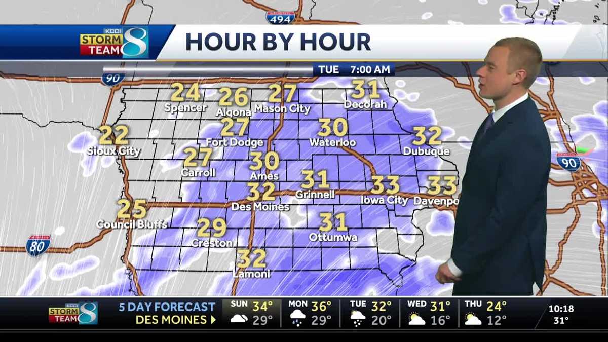
That’s when a rain/snow mix will move into Iowa from the southwest, changing to just snow during the evening, and overspreading much of the state through Monday night into Tuesday morning. The most snow will fall in southern Iowa, where 4-6″ is currently expected. The Des Moines area looks to get 2-4″ as of this forecast, with lesser amounts in northern Iowa.
Because of the heavy snow potential, a Winter Storm Watch has been issued for far western Iowa and much of southern Iowa Monday morning through Tuesday afternoon.
Closings | Interactive Radar | Weather Alerts
WATCH: Tips for keeping your house safe and warm during the cold weather
When the snow starts Monday evening, temperatures will initially be in the mid-30s, then fall to around freezing and stay around 32° into Tuesday morning. This will likely mean a wetter snow, particularly across the south.
This storm could make for slippery road conditions for Monday and Tuesday commutes.
As the snow ends Tuesday, winds will get stronger. Northerly winds will top 20 mph Tuesday afternoon, with gusts up to 40 mph.
A couple more snow possibilities follow late Wednesday night/Thursday morning, then next weekend. Temperatures also look much colder by the end of next week.
WATCH: How to be prepared for winter weather hazards
Iowa weather forecast
Sunday: Mostly cloudy morning. Some sun possible during the afternoon. High 34F. Winds W at 5 to 10 mph. Gusts up to 15 mph.
Sunday night: Cloudy skies. Low 28F. Winds ESE at 10 to 15 mph.
Monday: Cloudy skies. Rain/snow mix arrives during the afternoon, then changes to all snow. High 37F. Winds SE at 10 to 15 mph. Gusts up to 25 mph.
Monday night: Snow likely overnight. Heaviest in southern Iowa. Low 29F. Winds NE at 10 to 15 mph.
Tuesday: Snow during the morning, then cloudy and windy. Temps nearly steady in the low to mid-30s. Winds N at 20 to 25 mph, Gusts up to 40 mph. Total snow accumulation of 2 to 4″ expected in the Des Moines area.
Tuesday night: Partly cloudy. Low 18F. Winds NW at 15 to 20 mph.