
BOSTON – Well, it took nearly two years, but we finally got a legit snowstorm in southern New England!
Granted not everyone is enjoying the white stuff Sunday morning, but when all is said and done, I think there will be enough to go around.
Share your storm photos here
No major changes to the forecast on Sunday. As usual, the conditions will vary widely from place to place. At the coastline, some rain, mix and slop. Up in the Merrimack Valley and out through Worcester County, a winter wonderland!
The Winter Storm Warning remains in effect for the rest of Sunday for Essex, Middlesex, Worcester, Suffolk and Norfolk counties. A warning also is in place for all of southern New Hampshire. These are the areas that have the greatest risk of at least 6 inches of snow accumulation.
CBS Boston
What is left from Sunday’s storm?
Through noon, the rain/snow line will move northward through most of Bristol and Plymouth counties.
While it will still be snowing along and north of the Mass Pike, the intensity will be much less than it was overnight, and the rate of snowfall accumulation will also decrease significantly in many areas.
CBS Boston Graphic
We will get a final burst of snow across central and eastern MA this afternoon. This could drop a few more inches and bring some of the first snow accumulation to areas near the coastline. The snow will begin to taper off in central Massachusetts (Worcester County) around 4 p.m.
The back edge will continue to move east this evening and by 7-8 p.m. the snow will be just about done.
So, depending on where you live, it will be safe to start the cleanup between 4-8 p.m. tonight.
CBS Boston
Precipitation type
The farther inland you live, the lighter and fluffier the snow.
CBS Boston Graphic
Closer to the coastline, (inside 495) temperatures will be closer to, or slightly above 32 degrees and the snow will be much heavier/wetter.
At the immediate coastline from Boston down through the Cape Cod and the Islands, it will be mainly rain until the winds turn more northerly late in the storm on Sunday.
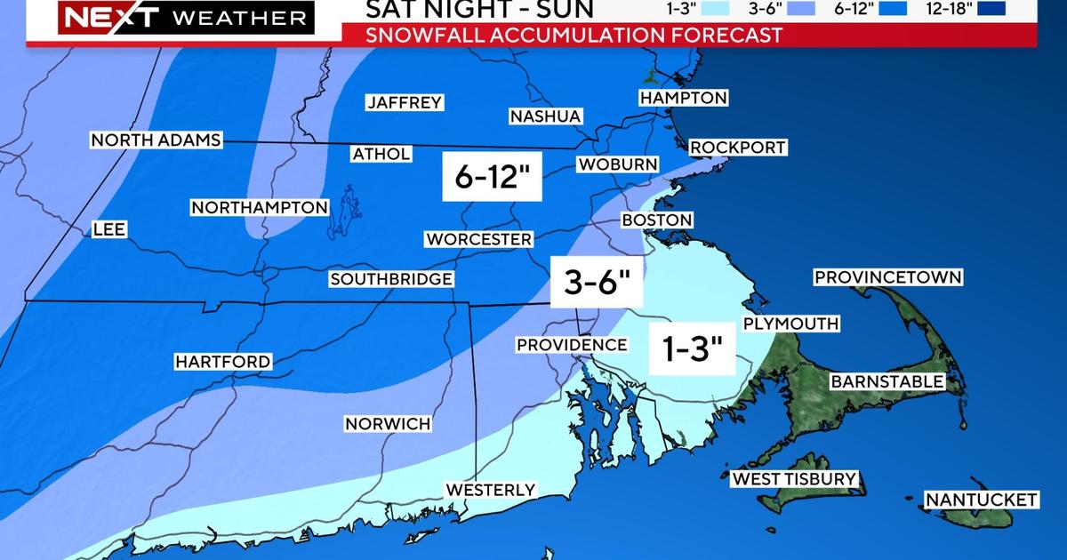
How much snow?
Final expected snowfall amounts:
CBS Boston Graphic
6-12″ North and west of I-95 and Route 128 including much of Essex, Middlesex and Worcester counties as well as southern New Hampshire
3-6″ Tight area from Cape Ann to just northwest of Boston and extending southward to inland (northern) Plymouth and Bristol counties
1-3″ Boston down through the South Shore and to the South Coast and over to the Cape Cod Canal
Very little (if any) for much of Cape Cod and the Islands
Wind impacts
The winds will not be a huge factor away from the coastline.
Northeast gusts will peak between 30-45mph right at the shoreline and 45-55mph over Cape Cod and the Islands.
Certainly not the strongest wind event we have had in recent weeks, but perhaps enough to cause some outages in the heavy/wet snow areas.
Tides are astronomically low this weekend. Therefore, the threat for any significant coastal flooding is low.
Flash freeze expected
Sunday’s storm will also come with a flash freeze.
As the winds turn northerly in the afternoon and evening, sub-freezing air will be pulled down the coastline.
CBS Boston Graphic
Temperatures will drop 5-10 degrees in a matter of minutes and, many areas that were in the mid to upper 30s, will quickly plunge into the 20s causing any untreated surfaces to ice up.
Patriots game forecast
Of course, we cannot forget the Patriots are playing their final home game on Sunday afternoon at Gillette!
Light snow will be falling for parts of the game and temperatures will be dropping from the low 30s into the 20s.
Next storm on the horizon
Lastly, unfortunately the stormy pattern will continue into next week.
Another strong storm will approach New England late Tuesday. This one may start briefly as a mix but then quickly change to a windswept rainstorm.
There may be several inches of rain Tuesday night into Wednesday, causing a rapid snowmelt and undoubtedly, a lot of flooding.
More on this to come.
As always, our WBZ Weather team will have you covered for the entire event on WBZ-TV, WBZ.com and CBS News Boston.