
Very cold air is coming to New Orleans and southeast Louisiana. It will feel even colder with strong winds delivering dangerous wind chills to the region.As the cold air begins to move in, there’s also the chance for some wintry precipitation in the form of freezing rain and sleet. All of this will require several WDSU First Warning Weather Alert Days. Take action now to make sure your neighbors are able to keep warm, the pipes in your home are safe from freezing, outdoor animals have access to heat, and those with delicate plants are able to shelter them too.A piece of the polar vortex, which spins around the Arctic Circle keeping some of the most frigid air on the planet locked in place, will break off allowing an open gate for this frigid to spill into southeast Louisiana.The beginning of the arctic intrusion won’t begin until Monday evening, so Monday should be a typical mid-winter day across southeast Louisiana with highs from the 50s to low 60s and a chance of afternoon rain.TEMPERATURES:Air temperatures will begin to tumble by Monday night. The thermometer should read 50s, but will drop to as low as the mid 20s for the coldest areas of the Northshore by Tuesday morning, and to freezing all the way into the city of New Orleans and toward coastal Louisiana.With lows forecast to 25 or colder over our farthest north areas, a hard freeze watch has been issued from 9 p.m. Monday night to 12 p.m. Tuesday.Tuesday will look nice from inside but out in the elements, it will be a whole different story. Highs won’t break out of the 30s for many of us with top temps only to around 40 in New Orleans.Tuesday night and Wednesday morning will be our coldest. A hard freeze is expected from the Northshore, and farther should all the way through New Orleans. Lows will drop into the mid 20s, so I would anticipate a hard freeze warning will be issued for most of southeast Louisiana from Tuesday night to midday Wednesday. This temperature forecast calls for freezing temps from 6 p.m. Tuesday night all the way through 9 a.m. Wednesday morning. That’s 15 hours of a freeze for the city of New Orleans. Be prepared! Once we get past Wednesday morning, we’ll be done with this round of arctic cold.WIND CHILL FACTOR:As the arctic front bellows through Monday night, strong north winds will also ramp up. North winds at 15-20-30 mph will make any temperature below 50 degrees feel even colder: the wind chill factor. This means temperatures well below freezing will feel even colder, and even daytime temps in the sun will feel awfully nasty too. Forecast winds of 15-20-30 mph will make lows from the mid 20s to lower 30s feel more like teens and 20s.This is why a wind chill advisory has been issued for areas where it could feel as cold as 13 or worse.North winds will stay gusty through the day on Tuesday. From inside, it will look rather nice but when you step out into the elements with temps not topping out over 40, will feel more like the 20s and lower 30s.Luckily for us, when the core of the coldest air settles in upon us Tuesday to Wednesday morning, the winds will relax too keeping the wind chills at bay.WINTRY PRECIPITATION:As the initial round of arctic air drops in Monday night, a light rain of rain will accompany the front. Big problems could be possible if the cold air interacts long enough with the light rain. Right now, many of us are under a winter weather advisory for the potential of freezing rain and/or sleet. Freezing rain is just regular rain, but the air temps drop below freezing so anything the rain drops hit will immediately freeze into a sheet of ice. This makes sidewalks, parking lots, and driveways the most dangerous, while elevated roads, bridges, and overpasses can become dicey too. If enough rain falls, and it gets below 30, icy roads become a major concern as well. This is why the advisory has been issued roughly from a diagonal line stretching from Poplarville, Mississippi, to Houma. Notice New Orleans is not included in the advisory at this time. Even though the city isn’t under the advisory, there is still a possible risk of ice, so be very careful! The advisory is from 6 p.m. Monday night to 6 a.m. Tuesday morning for a “light glaze” of ice. That’s amounts less than 0.01″.Even our forecast data for rain isn’t forecasting that much either, but it doesn’t take much ice to create big problems. Be careful getting around Tuesday morning!Here’s a timeline from our best data right now on possible freezing rain and sleet (rain drops that freeze into a teeny tiny little ball of ice that “pings” off your windshield and windows). That shows up as a pink/salmon color while rain is green.All of this boils down to making sure your neighbors have adequate heat, the pipes to your home are safe from freezing, outdoor animals have access to shelter and warmth, and anyone who has plants susceptible to the cold making sure they’re safe too.Keep warm, and be safe!
Very cold air is coming to New Orleans and southeast Louisiana. It will feel even colder with strong winds delivering dangerous wind chills to the region.
As the cold air begins to move in, there’s also the chance for some wintry precipitation in the form of freezing rain and sleet. All of this will require several WDSU First Warning Weather Alert Days. Take action now to make sure your neighbors are able to keep warm, the pipes in your home are safe from freezing, outdoor animals have access to heat, and those with delicate plants are able to shelter them too.
This content is imported from Facebook.
You may be able to find the same content in another format, or you may be able to find more information, at their web site.
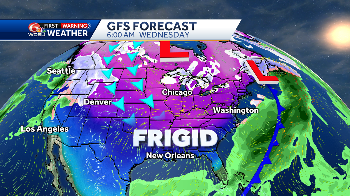
A piece of the polar vortex, which spins around the Arctic Circle keeping some of the most frigid air on the planet locked in place, will break off allowing an open gate for this frigid to spill into southeast Louisiana.

The beginning of the arctic intrusion won’t begin until Monday evening, so Monday should be a typical mid-winter day across southeast Louisiana with highs from the 50s to low 60s and a chance of afternoon rain.


TEMPERATURES:
Air temperatures will begin to tumble by Monday night. The thermometer should read 50s, but will drop to as low as the mid 20s for the coldest areas of the Northshore by Tuesday morning, and to freezing all the way into the city of New Orleans and toward coastal Louisiana.


With lows forecast to 25 or colder over our farthest north areas, a hard freeze watch has been issued from 9 p.m. Monday night to 12 p.m. Tuesday.

Tuesday will look nice from inside but out in the elements, it will be a whole different story. Highs won’t break out of the 30s for many of us with top temps only to around 40 in New Orleans.

Tuesday night and Wednesday morning will be our coldest. A hard freeze is expected from the Northshore, and farther should all the way through New Orleans. Lows will drop into the mid 20s, so I would anticipate a hard freeze warning will be issued for most of southeast Louisiana from Tuesday night to midday Wednesday. This temperature forecast calls for freezing temps from 6 p.m. Tuesday night all the way through 9 a.m. Wednesday morning. That’s 15 hours of a freeze for the city of New Orleans. Be prepared!


Once we get past Wednesday morning, we’ll be done with this round of arctic cold.
WIND CHILL FACTOR:
As the arctic front bellows through Monday night, strong north winds will also ramp up. North winds at 15-20-30 mph will make any temperature below 50 degrees feel even colder: the wind chill factor. This means temperatures well below freezing will feel even colder, and even daytime temps in the sun will feel awfully nasty too. Forecast winds of 15-20-30 mph will make lows from the mid 20s to lower 30s feel more like teens and 20s.


This is why a wind chill advisory has been issued for areas where it could feel as cold as 13 or worse.

North winds will stay gusty through the day on Tuesday. From inside, it will look rather nice but when you step out into the elements with temps not topping out over 40, will feel more like the 20s and lower 30s.


Luckily for us, when the core of the coldest air settles in upon us Tuesday to Wednesday morning, the winds will relax too keeping the wind chills at bay.
WINTRY PRECIPITATION:
As the initial round of arctic air drops in Monday night, a light rain of rain will accompany the front. Big problems could be possible if the cold air interacts long enough with the light rain. Right now, many of us are under a winter weather advisory for the potential of freezing rain and/or sleet. Freezing rain is just regular rain, but the air temps drop below freezing so anything the rain drops hit will immediately freeze into a sheet of ice. This makes sidewalks, parking lots, and driveways the most dangerous, while elevated roads, bridges, and overpasses can become dicey too. If enough rain falls, and it gets below 30, icy roads become a major concern as well. This is why the advisory has been issued roughly from a diagonal line stretching from Poplarville, Mississippi, to Houma. Notice New Orleans is not included in the advisory at this time. Even though the city isn’t under the advisory, there is still a possible risk of ice, so be very careful! The advisory is from 6 p.m. Monday night to 6 a.m. Tuesday morning for a “light glaze” of ice. That’s amounts less than 0.01″.

Even our forecast data for rain isn’t forecasting that much either, but it doesn’t take much ice to create big problems. Be careful getting around Tuesday morning!

Here’s a timeline from our best data right now on possible freezing rain and sleet (rain drops that freeze into a teeny tiny little ball of ice that “pings” off your windshield and windows). That shows up as a pink/salmon color while rain is green.


All of this boils down to making sure your neighbors have adequate heat, the pipes to your home are safe from freezing, outdoor animals have access to shelter and warmth, and anyone who has plants susceptible to the cold making sure they’re safe too.
Keep warm, and be safe!