
Alabama’s weather looks better and better through midweek, with chilly nights and mild, sunny days. The next soaking rain begins as early as Friday. Check the video forecast for the latest.SOME SUNSHINE THROUGH MIDWEEKWe are looking forward to some sunny, mild days and cool, clear nights through the middle of the week.Temperatures fall to the 30s and lower 40s early Tuesday morning, and some scattered frost is possible in the usual cold spots. It gets milder in the afternoon, with highs topping out near 60 degrees for most of North and Central Alabama.Wednesday and Thursday look even nicer, with more sunshine than clouds. Expect chilly, dry mornings and mild afternoons in the mid-60s.Clouds do thicken by Thursday evening as a disturbed weather pattern sets up multiple days of gray, rainy weather for much of the state.WET WEEKEND WEATHERThat unsettled, disturbed, active weather pattern starts with a strengthening jet stream right over the southern states Friday, Saturday, Sunday, and even the first part of next week.Light, scattered showers will begin as early as Friday morning, and that pesky hit-or-miss rain will last all day and all night. Friday will be mild and humid, with a high in the lower to middle 60s.Heavier rain sets in for Saturday, and it could be a total wash out of a day. Steady, soaking rain and a stiff south breeze will make outdoor activities difficult, if not impossible. Total rainfall from Friday through Saturday adds up to around 1 to 2 inches.Scattered showers linger under a cloudy sky on Sunday, and some periods of heavier rain are possible, mainly south of Interstate 20 through Sunday night. Both weekend days feature humid, mild days in the 60s.MORE RAIN NEXT WEEKThe active weather pattern lasts through Monday and Tuesday. We could add another 1 to 2 inches of rainfall by Tuesday night for a grand total of 2 to 3 inches on average (some 4-plus) by Tuesday night.WHERE IS WINTER?That brutal arctic blitz in January dropped Birmingham’s average temperature 13 degrees below normal from Jan. 13 to Jan. 21.Since then, winter disappeared.Is it coming back?We do expect a return to colder-than-usual weather around mid-February. The transition may be slow, but the same kind of pattern that drove bitterly cold air and wintry weather into the South last month will develop again after Valentine’s Day.How cold will it get? That is still debatable, but a few more rounds of Arctic air could drop temperatures to the 10s for lows and 30s for highs a few more times from mid-February through early March.Can you expect snow?It is not out of the question. Some of Alabama’s recent heavy snows have come in late February and early March, so we will be watching for that with this kind of pattern. STAY WEATHER-AWAREFor the latest weather coverage for your area, click here. And stay updated with alerts in the WVTM 13 app. You can download it here.For the latest Birmingham weather information and Central Alabama’s certified most accurate forecast, watch WVTM 13 News.Don’t forget to follow us on Facebook, X, formerly Twitter, and Instagram.
Alabama’s weather looks better and better through midweek, with chilly nights and mild, sunny days. The next soaking rain begins as early as Friday. Check the video forecast for the latest.
SOME SUNSHINE THROUGH MIDWEEK
We are looking forward to some sunny, mild days and cool, clear nights through the middle of the week.
Temperatures fall to the 30s and lower 40s early Tuesday morning, and some scattered frost is possible in the usual cold spots. It gets milder in the afternoon, with highs topping out near 60 degrees for most of North and Central Alabama.

Wednesday and Thursday look even nicer, with more sunshine than clouds. Expect chilly, dry mornings and mild afternoons in the mid-60s.
Clouds do thicken by Thursday evening as a disturbed weather pattern sets up multiple days of gray, rainy weather for much of the state.
WET WEEKEND WEATHER
That unsettled, disturbed, active weather pattern starts with a strengthening jet stream right over the southern states Friday, Saturday, Sunday, and even the first part of next week.

Light, scattered showers will begin as early as Friday morning, and that pesky hit-or-miss rain will last all day and all night. Friday will be mild and humid, with a high in the lower to middle 60s.
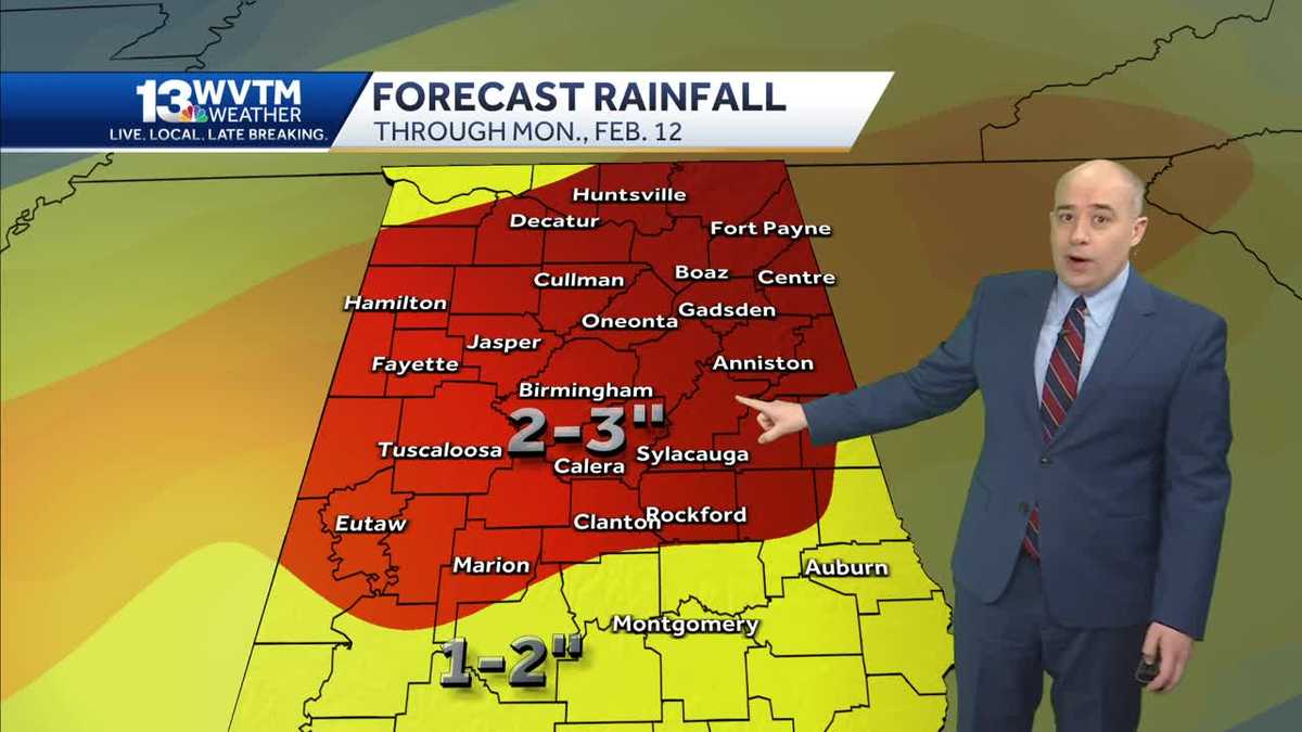
Heavier rain sets in for Saturday, and it could be a total wash out of a day. Steady, soaking rain and a stiff south breeze will make outdoor activities difficult, if not impossible. Total rainfall from Friday through Saturday adds up to around 1 to 2 inches.

Scattered showers linger under a cloudy sky on Sunday, and some periods of heavier rain are possible, mainly south of Interstate 20 through Sunday night.
Both weekend days feature humid, mild days in the 60s.
MORE RAIN NEXT WEEK
The active weather pattern lasts through Monday and Tuesday.
We could add another 1 to 2 inches of rainfall by Tuesday night for a grand total of 2 to 3 inches on average (some 4-plus) by Tuesday night.

WHERE IS WINTER?
That brutal arctic blitz in January dropped Birmingham’s average temperature 13 degrees below normal from Jan. 13 to Jan. 21.
Since then, winter disappeared.
Is it coming back?
We do expect a return to colder-than-usual weather around mid-February. The transition may be slow, but the same kind of pattern that drove bitterly cold air and wintry weather into the South last month will develop again after Valentine’s Day.

How cold will it get? That is still debatable, but a few more rounds of Arctic air could drop temperatures to the 10s for lows and 30s for highs a few more times from mid-February through early March.
Can you expect snow?
It is not out of the question. Some of Alabama’s recent heavy snows have come in late February and early March, so we will be watching for that with this kind of pattern.
STAY WEATHER-AWARE
For the latest weather coverage for your area, click here. And stay updated with alerts in the WVTM 13 app. You can download it here.
For the latest Birmingham weather information and Central Alabama’s certified most accurate forecast, watch WVTM 13 News.
Don’t forget to follow us on Facebook, X, formerly Twitter, and Instagram.