
Ophelia weakened into a post-tropical cyclone late Saturday night as the storm continues to move north.Maximum sustained winds have decreased to near 35 mph with higher gusts. Winds in Southern Maryland have been on the decline as the storm weakens.Ophelia’s remnants will move north-northeast, generally up the Interstate 95 corridor, before exiting offshore Sunday night. Little change in strength is forecast during the next day or so. The post-tropical low is expected to become absorbed by a frontal boundary Sunday night or early Monday.NATIONAL HURRICANE CENTER ADVISORY — 11 p.m. Saturday (Last update)Post-Tropical Cyclone OpheliaLocation: 37.1N 77.6W, about 30 miles SSW of Richmond, VAMaximum sustained winds: 35 mphMovement: N at 8 mphMinimum central pressure: 1,003 mbHURRICANE PREPARATION: How to prepare for hurricanesHere are the possibilities:Storm surge of 1-3 feetAbout 2-4 inches of rainFloodingPeak wind gusts of 50-55 mphTornadoes, mainly in Southern Maryland/on the Lower Eastern Shore| APP USERS: Tap here for interactive weather links STORM TRACKOphelia made landfall early Saturday morning near Emerald Isle, North Carolina, with 70 mph winds.Ophelia then continued northward as the center of the storm moved into southeastern Virginia in the 5 p.m. hour.This will be followed by a gradual turn toward the northeast by Sunday.SEVERE WEATHER ALERTSThe National Weather Service issued a Flood Watch from 8 p.m. Saturday through Sunday morning for the Interstate 95 corridor as the center of Ophelia moves north tracking along or close to I-95.The north side of the storm will bring a bout of moderate to perhaps heavy rain overnight, adding about 1-2 inches more of rain to the 1-2 inches of rain that has already fallen, which is the reason for the flood watch remaining in effect.As of the 8 p.m. Saturday update, all storm surge and tropical storm warnings have been discontinued.Video below: Ophelia’s impact on the surf at Rehoboth Beach (Bill Shull)At 5 p.m. Saturday, the Maryland Transportation Authority said the Chesapeake Bay Bridge was under full wind restrictions: No house trailers or tractor-trailers under 64,000 pounds. Only automobiles, pickup trucks, flatbed trailers, commercial buses and heavy-laden tractor/trailers are permitted to cross the bridge.As of 6:45 p.m., the Key and Nice/Middleton bridges are under wind warnings, which means operators of house trailers, box trailers, motorcycles, vehicles with roof-mount racks containing cargo or any other vehicle that may be subject to high winds should use caution while crossing the bridge.TROPICAL ATLANTIC STORM PATHMARYLAND FLOOD ALERTSMARYLAND’S 7-DAY FORECASTWBAL-TV 11’s OCEAN CITY WEBCAMWBAL-TV 11’s ANNAPOLIS WEBCAMWBAL-TV 11’s MARYLAND WEATHER RADAR| APP USERS: Tap here for radar.Download the WBAL-TV app NOW and turn on push alerts to be aware of severe weather warnings, listen to NOAA Weather radio, and watch WBAL-TV 11 when impending severe weather develops.Follow: @wbaltv11 | @TTasselWBAL | @AvaWBAL | @TonyPannWBAL | @DalenciaWBAL | @ChelseaWeatherWhat this means for Maryland, and whenSATURDAYAt 6 p.m. Saturday, Meteorologist Tony Pann said Ophelia will continue to track north and northeast over the next 12 hours as it weakens over land.Marylanders can expect pockets of heavy rain with wind gusts over 40 mph as the center of the storm gets closer to and passes through Maryland. There will be some isolated flooding with 1-2 more inches of rain in low-lying areas, like Annapolis and Southern Maryland.Video below: Impacts of storm on Ocean City (WBOC)A few tornadoes are also possible, particularly south and east of metropolitan Baltimore.Localized storm surge of 1-3 feet above ground will be possible along the western shore of the Chesapeake Bay as well as the shore of the tidal Potomac River. Highest water levels are expected around times of high tide Saturday and Saturday night.SUNDAY — Storm moves outIt will still be raining Sunday morning and afternoon, and it will probably still be raining at the beginning of the Ravens game, but it will taper off by the end of the game as the storm lifts out of Maryland around that time.Video below: Ophelia floods parts of Delaware shoreline (WRDE)SATURDAY EVENTS CANCELEDHeavy rainfall and storm surge led to the cancellation of several events Saturday, including Artscape.SATURDAY events canceled:Annapolis Kunta Kinte FestivalAnnapolis Water Taxi service will end at 6 p.m. Friday/out of service all day SaturdayArtscape on Saturday — Festival will open from noon to 5 p.m. SundayBig Bike Build fundraiser at Stevenson UniversityHarford County Wine FestivalMaryland Renaissance Festival Susquehanna River Running Festival”We’re going to have Artscape (Friday night). We’re going to have Artscape on Sunday. But we are not going to have folks be in danger just for a festival, whether it’s Artscape or anything else,” Baltimore Mayor Brandon Scott said early Friday evening.ALERTS: Severe weather alerts from the WBAL-TV app: step-by-step guideCLOSINGS: See if schools, businesses or organizations have closed or delayedRADAR: Track the storm on WBAL-TV’s interactive radarROADS: Check for crashes and backups with our interactive traffic mapTORNADO SURVIVAL: 5 things you need to do nowGovernor declares state of emergency in MarylandMaryland Gov. Wes Moore declared a state of emergency Friday night in preparation for Ophelia. The governor is asking Marylanders to avoid going out during the storm and to take precautions.”We are asking all Marylanders to remain vigilant, to stay tuned to local news stations for the latest updates, and to follow any instructions local officials may provide during this state of emergency,” Moore said in a statement. “If you can avoid driving or being out during the storm please do so. We are expecting an extended period of strong winds, heavy rainfall and elevated tides. Those under a tropical storm warning should be prepared and exercise caution during this multiple-day event. Our administration is committed to doing all that we can to ensure Marylanders remain safe during this incident and will be working closely with local jurisdictions to recover after the storm.”The governor directed the Maryland National Guard to activate eight soldiers on active duty. According to an MDNG statement, the soldiers will have three high-clearance vehicles ready in Somerset County in case they are needed. The MDNG will use light/medium tactical vehicles for evacuation transportation flooding occurs.Power outagesBaltimore Gas and Electric said it’s monitoring the storm and has scheduled utility crews in preparation for service. BGE reminds customers to report outages at BGE.com, BGE’s app, text 69243 or call 877-778-2222.As of 6 p.m. Saturday, BGE reported as many as 3,316 customers without service across central Maryland. The most outages were located in Anne Arundel and Baltimore counties. Baltimore City stands ready for stormThe mayor spoke Friday evening about the city’s preparations.”We are urging all Baltimoreans to take steps to make sure that they are safe and stay out of harm’s way,” Scott said. “Heavy rainfall and a storm surge over a 24- to 36-hour period from late (Friday night) through Sunday morning could result in some flooding across the area.”On Saturday, the mayor announced Baltimore’s Robert C. Marshall Recreation Center (1201 Pennsylvania Ave.) is designated as an emergency homeless shelter. Its hours are from 2 p.m. Saturday to 8 a.m. Sunday.Residents in low-lying areas that are prone to flooding can park in city-owned garages in Fells Point, Harbor East and Little Italy. Parking remains free in these garages until 7 a.m. Monday. Parking is available on a first come, first served basis. Residents will be asked to provide proof of residency, such as a driver’s license, at the garages.The garages included are:Fleet and Eden Garage (501 S. Eden St.)Caroline Street Garage (805 S. Caroline St.)Little Italy Parking Garage, 400 S. Central Ave.)Shoreline cities prepare, Red Cross mobilizesOcean City Mayor Rich Meehan is among the decision-makers keeping a close eye on conditions and trying to stay one step ahead.”Things are pretty quiet right now. The wind is starting to pick up. We’re keeping an eye, obviously, on the storm as it moves, you know, towards us,” Meehan told 11 News early Friday. “I think going into late tonight through tomorrow afternoon is probably going to be the biggest part. Late afternoon tomorrow is going to be the biggest part of the storm that we’re going to experience.”Video below: Annapolis, Ocean City officials talk preps ahead of OpheliaThe National Capital and Greater Chesapeake Region of the American Red Cross is also preparing for the storm with teams on standby Friday in Baltimore, ready to deploy.”Our Baltimore team has already made contact with the volunteers, and they have folks ready to go to respond, if needed, and then, if needed, to go down to the Delmarva Peninsula, or out to the shore, where the impacts are likely to be greater,” said Dale Kunce, regional CEO with the National Capital and Greater Chesapeake Region of the Red Cross.”I think the message for everybody in the state, particularly, the Eastern Shore, then just over the other side of the (Chesapeake) Bay is just to be careful. Use common sense. And, hey, 24 hours, 36 hours from now, this will be gone. Let’s just let it ride through and be safe,” Meehan said.Video below: OC mayor live on 11 News with conditions Saturday morningEmergency operations in Annapolis included the distribution Friday afternoon of sandbags at City Dock. City officials said downtown is expected to flood by 2 a.m. Saturday.”Most of the flooding will occur right here downtown. We can also expect some flooding down in Eastport as well. So, the usual spots that we see, so Dock Street, Susan Campbell Park, as well as Compromise Street,” said Nicole Torres, with the Annapolis Office of Emergency Management.Stay informed, understand the terminologyTropical storms and hurricanes each have two descriptors, a watch and a warning. Watches and warnings are issued in advance of the onset of tropical storm force winds (39-73 mph).WATCH: This means tropical storm or hurricane conditions are possible in the “watch area.” A watch is issued up to 48 hours in advance of the onset of tropical storm-force winds.WARNING: This means tropical storm or hurricane conditions are expected in the “warning area.” A warning is issued up to 36 hours in advance of the onset of tropical storm-force winds.Tropical Depression: A tropical cyclone with maximum sustained surface winds of 38 mph or less.Tropical Storm: A tropical cyclone that has maximum sustained surface winds ranging from 39-73 mph.Category 1 hurricane: Sustained winds of 74-95 mph — very dangerous winds will produce some damage.Category 2 hurricane: 96-110 mph winds — Extremely dangerous winds will cause extensive damage. Near-total power loss is expected with outages that could last from several days to weeks.Category 3 major hurricane: 111-129 mph winds — Devastating damage will occur. Electricity and water will be unavailable for several days to weeks after the storm passes.Category 4 major hurricane: 130-156 mph winds — Catastrophic damage will occur. Power outages will last weeks to possibly months. Most of the area will be uninhabitable for weeks or months.Category 5 major hurricane: 157 mph winds or higher — Catastrophic damage will occur. A high percentage of framed homes will be destroyed, with total roof failure and wall collapse. Fallen trees and power poles will isolate residential areas. Power outages will last for weeks to possibly months. Most of the area will be uninhabitable for weeks or months.Hurricane season can be a daunting time of year if you live in a hurricane-prone region like the Mid-Atlantic. A single hurricane making landfall can leave a trail of devastation, especially in the most flood-prone areas of Baltimore.While it’s rare for an actual hurricane (that is, a storm with sustained winds above 74 mph) to make landfall in Baltimore, it’s not uncommon for the remnants of one to bring storm surges, heavy rainfall and high winds, which can be plenty destructive. (The most recent hurricanes to cause major damage in Maryland were Irene in 2011 and Isabel in 2003.) Low-lying areas of the city — such as Mount Washington, Clipper Mill and Fells Point — are particularly vulnerable to flooding.How to prepare for hurricanesHere are some of the most important hurricane preparedness recommendations for homeowners in Florida and in other hurricane-prone states.Know your zoneThe Maryland Department of Emergency Management makes it easy to know if you need to evacuate during a hurricane or tropical storm. Visit KnowYourZoneMD.com and enter your address to find out what evacuation zone you live in (they’re color-coded and labeled either A, B or C).During severe weather, you’ll then receive instructions on whether to evacuate or shelter in place. The highest risk areas will be evacuated first, followed by lower risk zones, if needed. (Note that even if you don’t live in one of the three official zones, you might still need to evacuate, depending on the weather situation.)Know your evacuation routeBefore or during a hurricane, you might be ordered to evacuate your home. Find out the locations of your closest shelters and figure out how you will get to them. While Baltimore does not designate specific evacuation routes, you can plan ahead by looking up alternative driving routes. If possible, keep a map in your vehicle so you can redirect yourself on the fly, if necessary.Store and collect suppliesMake sure you have enough food, water and medical supplies for each family member to last at least two or three days. Your hurricane supply kit should also be stocked with a radio, extra batteries, a flashlight, space blankets and important documents.Don’t forget your petsYour pets are important members of the family, and they need to be taken care of during an emergency. Learn which shelters do and don’t accept pets. Or, you can consider a pet-friendly hotel that’s outside the evacuation zone.Download the FEMA mobile appFEMA’s mobile app has many disaster resources, including safety tips and weather alerts. It also has a checklist of emergency supplies and shelters and will keep you updated with real-time alerts from the National Weather Service.Protect your homeOnce you’ve made your emergency plan and assembled your emergency kit, it’s time to prepare your home. While this list can feel overwhelming, it doesn’t have to be done all at once. Instead, start working your way through the list now, and check off items once completed.Landscaping — Replace gravel or stone garden beds with lighter material that will not damage your property in high winds.Trees and shrubs — Remove any weak, dying, or damaged trees and branches which could break off in high winds and crash into your house.Windows — Consider installing storm shutters to prevent window glass from breaking. Plywood sheets can also be used in a pinch.Doors — Think about swapping your current doors for hurricane-proof doors with three hinges and a deadbolt. Ideally, glass sliding doors should be made of tempered glass and protected by storm shutters or plywood.Garage doors — Ensure your garage or roller doors are in good working condition and locked securely.Vents and wall openings — Fill any vents or exterior holes with high-quality urethane-based caulk to prevent water penetration.Boats — If you keep a boat in your yard, anchor your boat securely to a tree or the ground before the storm arrives.Insurance coverageIf you live in an area that experiences hurricanes and tropical storms, it’s important to have the right insurance coverage. Tap here to see some types of insurance that will cover your home and your personal belongings in the event of a major storm.
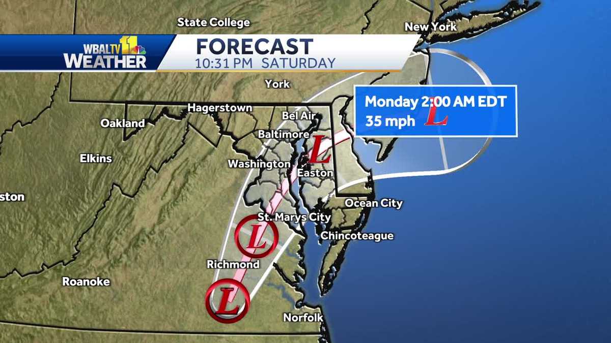
Ophelia weakened into a post-tropical cyclone late Saturday night as the storm continues to move north.
Maximum sustained winds have decreased to near 35 mph with higher gusts. Winds in Southern Maryland have been on the decline as the storm weakens.
Ophelia’s remnants will move north-northeast, generally up the Interstate 95 corridor, before exiting offshore Sunday night. Little change in strength is forecast during the next day or so. The post-tropical low is expected to become absorbed by a frontal boundary Sunday night or early Monday.
NATIONAL HURRICANE CENTER ADVISORY — 11 p.m. Saturday (Last update)
- Post-Tropical Cyclone Ophelia
- Location: 37.1N 77.6W, about 30 miles SSW of Richmond, VA
- Maximum sustained winds: 35 mph
- Movement: N at 8 mph
- Minimum central pressure: 1,003 mb
HURRICANE PREPARATION: How to prepare for hurricanes
Here are the possibilities:
- Storm surge of 1-3 feet
- About 2-4 inches of rain
- Flooding
- Peak wind gusts of 50-55 mph
- Tornadoes, mainly in Southern Maryland/on the Lower Eastern Shore
| APP USERS: Tap here for interactive weather links
STORM TRACK
Ophelia made landfall early Saturday morning near Emerald Isle, North Carolina, with 70 mph winds.
Ophelia then continued northward as the center of the storm moved into southeastern Virginia in the 5 p.m. hour.
This will be followed by a gradual turn toward the northeast by Sunday.
SEVERE WEATHER ALERTS
The National Weather Service issued a Flood Watch from 8 p.m. Saturday through Sunday morning for the Interstate 95 corridor as the center of Ophelia moves north tracking along or close to I-95.
The north side of the storm will bring a bout of moderate to perhaps heavy rain overnight, adding about 1-2 inches more of rain to the 1-2 inches of rain that has already fallen, which is the reason for the flood watch remaining in effect.
As of the 8 p.m. Saturday update, all storm surge and tropical storm warnings have been discontinued.
Video below: Ophelia’s impact on the surf at Rehoboth Beach (Bill Shull)
At 5 p.m. Saturday, the Maryland Transportation Authority said the Chesapeake Bay Bridge was under full wind restrictions: No house trailers or tractor-trailers under 64,000 pounds. Only automobiles, pickup trucks, flatbed trailers, commercial buses and heavy-laden tractor/trailers are permitted to cross the bridge.
As of 6:45 p.m., the Key and Nice/Middleton bridges are under wind warnings, which means operators of house trailers, box trailers, motorcycles, vehicles with roof-mount racks containing cargo or any other vehicle that may be subject to high winds should use caution while crossing the bridge.
TROPICAL ATLANTIC STORM PATH
MARYLAND FLOOD ALERTS
MARYLAND’S 7-DAY FORECAST
WBAL-TV 11’s OCEAN CITY WEBCAM
WBAL-TV 11’s ANNAPOLIS WEBCAM
WBAL-TV 11’s MARYLAND WEATHER RADAR
| APP USERS: Tap here for radar.
Download the WBAL-TV app NOW and turn on push alerts to be aware of severe weather warnings, listen to NOAA Weather radio, and watch WBAL-TV 11 when impending severe weather develops.
Follow: @wbaltv11 | @TTasselWBAL | @AvaWBAL | @TonyPannWBAL | @DalenciaWBAL | @ChelseaWeather
What this means for Maryland, and when
SATURDAY
At 6 p.m. Saturday, Meteorologist Tony Pann said Ophelia will continue to track north and northeast over the next 12 hours as it weakens over land.
Marylanders can expect pockets of heavy rain with wind gusts over 40 mph as the center of the storm gets closer to and passes through Maryland. There will be some isolated flooding with 1-2 more inches of rain in low-lying areas, like Annapolis and Southern Maryland.
Video below: Impacts of storm on Ocean City (WBOC)
A few tornadoes are also possible, particularly south and east of metropolitan Baltimore.
Localized storm surge of 1-3 feet above ground will be possible along the western shore of the Chesapeake Bay as well as the shore of the tidal Potomac River. Highest water levels are expected around times of high tide Saturday and Saturday night.
SUNDAY — Storm moves out
It will still be raining Sunday morning and afternoon, and it will probably still be raining at the beginning of the Ravens game, but it will taper off by the end of the game as the storm lifts out of Maryland around that time.
Video below: Ophelia floods parts of Delaware shoreline (WRDE)
SATURDAY EVENTS CANCELED
Heavy rainfall and storm surge led to the cancellation of several events Saturday, including Artscape.
SATURDAY events canceled:
- Annapolis Kunta Kinte Festival
- Annapolis Water Taxi service will end at 6 p.m. Friday/out of service all day Saturday
- Artscape on Saturday — Festival will open from noon to 5 p.m. Sunday
- Big Bike Build fundraiser at Stevenson University
- Harford County Wine Festival
- Maryland Renaissance Festival
- Susquehanna River Running Festival
“We’re going to have Artscape (Friday night). We’re going to have Artscape on Sunday. But we are not going to have folks be in danger just for a festival, whether it’s Artscape or anything else,” Baltimore Mayor Brandon Scott said early Friday evening.
Governor declares state of emergency in Maryland
Maryland Gov. Wes Moore declared a state of emergency Friday night in preparation for Ophelia. The governor is asking Marylanders to avoid going out during the storm and to take precautions.
“We are asking all Marylanders to remain vigilant, to stay tuned to local news stations for the latest updates, and to follow any instructions local officials may provide during this state of emergency,” Moore said in a statement. “If you can avoid driving or being out during the storm please do so. We are expecting an extended period of strong winds, heavy rainfall and elevated tides. Those under a tropical storm warning should be prepared and exercise caution during this multiple-day event. Our administration is committed to doing all that we can to ensure Marylanders remain safe during this incident and will be working closely with local jurisdictions to recover after the storm.”
The governor directed the Maryland National Guard to activate eight soldiers on active duty. According to an MDNG statement, the soldiers will have three high-clearance vehicles ready in Somerset County in case they are needed. The MDNG will use light/medium tactical vehicles for evacuation transportation flooding occurs.
Power outages
Baltimore Gas and Electric said it’s monitoring the storm and has scheduled utility crews in preparation for service. BGE reminds customers to report outages at BGE.com, BGE’s app, text 69243 or call 877-778-2222.
As of 6 p.m. Saturday, BGE reported as many as 3,316 customers without service across central Maryland. The most outages were located in Anne Arundel and Baltimore counties.
Baltimore City stands ready for storm
The mayor spoke Friday evening about the city’s preparations.
“We are urging all Baltimoreans to take steps to make sure that they are safe and stay out of harm’s way,” Scott said. “Heavy rainfall and a storm surge over a 24- to 36-hour period from late (Friday night) through Sunday morning could result in some flooding across the area.”
On Saturday, the mayor announced Baltimore’s Robert C. Marshall Recreation Center (1201 Pennsylvania Ave.) is designated as an emergency homeless shelter. Its hours are from 2 p.m. Saturday to 8 a.m. Sunday.
Residents in low-lying areas that are prone to flooding can park in city-owned garages in Fells Point, Harbor East and Little Italy. Parking remains free in these garages until 7 a.m. Monday. Parking is available on a first come, first served basis. Residents will be asked to provide proof of residency, such as a driver’s license, at the garages.
The garages included are:
- Fleet and Eden Garage (501 S. Eden St.)
- Caroline Street Garage (805 S. Caroline St.)
- Little Italy Parking Garage, 400 S. Central Ave.)
Shoreline cities prepare, Red Cross mobilizes
Ocean City Mayor Rich Meehan is among the decision-makers keeping a close eye on conditions and trying to stay one step ahead.
“Things are pretty quiet right now. The wind is starting to pick up. We’re keeping an eye, obviously, on the storm as it moves, you know, towards us,” Meehan told 11 News early Friday. “I think going into late tonight through tomorrow afternoon is probably going to be the biggest part. Late afternoon tomorrow is going to be the biggest part of the storm that we’re going to experience.”
Video below: Annapolis, Ocean City officials talk preps ahead of Ophelia
The National Capital and Greater Chesapeake Region of the American Red Cross is also preparing for the storm with teams on standby Friday in Baltimore, ready to deploy.
“Our Baltimore team has already made contact with the volunteers, and they have folks ready to go to respond, if needed, and then, if needed, to go down to the Delmarva Peninsula, or out to the shore, where the impacts are likely to be greater,” said Dale Kunce, regional CEO with the National Capital and Greater Chesapeake Region of the Red Cross.
“I think the message for everybody in the state, particularly, the Eastern Shore, then just over the other side of the (Chesapeake) Bay is just to be careful. Use common sense. And, hey, 24 hours, 36 hours from now, this will be gone. Let’s just let it ride through and be safe,” Meehan said.
Video below: OC mayor live on 11 News with conditions Saturday morning
Emergency operations in Annapolis included the distribution Friday afternoon of sandbags at City Dock. City officials said downtown is expected to flood by 2 a.m. Saturday.
“Most of the flooding will occur right here downtown. We can also expect some flooding down in Eastport as well. So, the usual spots that we see, so Dock Street, Susan Campbell Park, as well as Compromise Street,” said Nicole Torres, with the Annapolis Office of Emergency Management.
Stay informed, understand the terminology
Tropical storms and hurricanes each have two descriptors, a watch and a warning. Watches and warnings are issued in advance of the onset of tropical storm force winds (39-73 mph).
WATCH: This means tropical storm or hurricane conditions are possible in the “watch area.” A watch is issued up to 48 hours in advance of the onset of tropical storm-force winds.
WARNING: This means tropical storm or hurricane conditions are expected in the “warning area.” A warning is issued up to 36 hours in advance of the onset of tropical storm-force winds.
Loading…
Tropical Depression: A tropical cyclone with maximum sustained surface winds of 38 mph or less.
Tropical Storm: A tropical cyclone that has maximum sustained surface winds ranging from 39-73 mph.
Category 1 hurricane: Sustained winds of 74-95 mph — very dangerous winds will produce some damage.
Category 2 hurricane: 96-110 mph winds — Extremely dangerous winds will cause extensive damage. Near-total power loss is expected with outages that could last from several days to weeks.
Category 3 major hurricane: 111-129 mph winds — Devastating damage will occur. Electricity and water will be unavailable for several days to weeks after the storm passes.
Category 4 major hurricane: 130-156 mph winds — Catastrophic damage will occur. Power outages will last weeks to possibly months. Most of the area will be uninhabitable for weeks or months.
Category 5 major hurricane: 157 mph winds or higher — Catastrophic damage will occur. A high percentage of framed homes will be destroyed, with total roof failure and wall collapse. Fallen trees and power poles will isolate residential areas. Power outages will last for weeks to possibly months. Most of the area will be uninhabitable for weeks or months.
Hurricane season can be a daunting time of year if you live in a hurricane-prone region like the Mid-Atlantic. A single hurricane making landfall can leave a trail of devastation, especially in the most flood-prone areas of Baltimore.
While it’s rare for an actual hurricane (that is, a storm with sustained winds above 74 mph) to make landfall in Baltimore, it’s not uncommon for the remnants of one to bring storm surges, heavy rainfall and high winds, which can be plenty destructive. (The most recent hurricanes to cause major damage in Maryland were Irene in 2011 and Isabel in 2003.) Low-lying areas of the city — such as Mount Washington, Clipper Mill and Fells Point — are particularly vulnerable to flooding.
How to prepare for hurricanes
Here are some of the most important hurricane preparedness recommendations for homeowners in Florida and in other hurricane-prone states.
Know your zone
The Maryland Department of Emergency Management makes it easy to know if you need to evacuate during a hurricane or tropical storm. Visit KnowYourZoneMD.com and enter your address to find out what evacuation zone you live in (they’re color-coded and labeled either A, B or C).
During severe weather, you’ll then receive instructions on whether to evacuate or shelter in place. The highest risk areas will be evacuated first, followed by lower risk zones, if needed. (Note that even if you don’t live in one of the three official zones, you might still need to evacuate, depending on the weather situation.)
Know your evacuation route
Before or during a hurricane, you might be ordered to evacuate your home. Find out the locations of your closest shelters and figure out how you will get to them. While Baltimore does not designate specific evacuation routes, you can plan ahead by looking up alternative driving routes. If possible, keep a map in your vehicle so you can redirect yourself on the fly, if necessary.
Store and collect supplies
Make sure you have enough food, water and medical supplies for each family member to last at least two or three days. Your hurricane supply kit should also be stocked with a radio, extra batteries, a flashlight, space blankets and important documents.
Don’t forget your pets
Your pets are important members of the family, and they need to be taken care of during an emergency. Learn which shelters do and don’t accept pets. Or, you can consider a pet-friendly hotel that’s outside the evacuation zone.
Download the FEMA mobile app
FEMA’s mobile app has many disaster resources, including safety tips and weather alerts. It also has a checklist of emergency supplies and shelters and will keep you updated with real-time alerts from the National Weather Service.
Protect your home
Once you’ve made your emergency plan and assembled your emergency kit, it’s time to prepare your home. While this list can feel overwhelming, it doesn’t have to be done all at once. Instead, start working your way through the list now, and check off items once completed.
- Landscaping — Replace gravel or stone garden beds with lighter material that will not damage your property in high winds.
- Trees and shrubs — Remove any weak, dying, or damaged trees and branches which could break off in high winds and crash into your house.
- Windows — Consider installing storm shutters to prevent window glass from breaking. Plywood sheets can also be used in a pinch.
- Doors — Think about swapping your current doors for hurricane-proof doors with three hinges and a deadbolt. Ideally, glass sliding doors should be made of tempered glass and protected by storm shutters or plywood.
- Garage doors — Ensure your garage or roller doors are in good working condition and locked securely.
- Vents and wall openings — Fill any vents or exterior holes with high-quality urethane-based caulk to prevent water penetration.
- Boats — If you keep a boat in your yard, anchor your boat securely to a tree or the ground before the storm arrives.
Insurance coverage
If you live in an area that experiences hurricanes and tropical storms, it’s important to have the right insurance coverage. Tap here to see some types of insurance that will cover your home and your personal belongings in the event of a major storm.