
IN SACRAMENTO, 28 DEGREES IN SOUTH LAKE TAHOE. RADAR IS QUIET THROUGH THE VALLEY, BUT WE ARE STARTING TO SEE SOME SHOWERS BUILDING INTO COLUSA AND GLENN COUNTIES. IT’S MAINLY LIGHTRILLIONAIN FOR THE TIME BEING. THE STEADIER RAIN IS LIKELY TO PICK UP FOR A SPOT LIKE SACRAMENTO IN STOCKTON AT ABOUT 2 OR 3:00 THIS AFTERNOON. FUTURECAST SHOWS THAT NICELY. WE’LL HAVE A FEW HOURS OF RAIN FROM THEN ON, AND NOTICE THE SNOW STARTS TO PICK UP IN THE SIERRA. SNOW LEVEL UP ABOVE 6000FT. SO EXPECT CHAIN CONTROL THIS AFTERNOON ALL THE WAY THROUGH TONIGHT, 630 THIS EVENING. THERE MAY BE A GAP IN THE RAIN FOR THE VALLEY, BUT IT WILL STAY SHOWERY THROUGH ABOUT 10 OR 11:00 THIS EVENING. AGAIN, THAT RAIN LIGHT ROADS ARE JUST GOING TO BE WET OVERNIGHT AND INTO EARLY SUNDAY MORNING. LOOK AT SUNDAY THOUGH. THIS IS 9:30 A.M. WE’RE DRY IN THE VALLEY. WE’RE DRY IN THE FOOTHILLS. WE’RE DRY IN THE SIERRA. MODELS ARE VERY CONSISTENTLY BEEN SHOWING THIS NICE LITTLE BREAK. SO WE’RE CONFIDENT THAT SUNDAY MORNING IS GOING TO BE A GOOD TIME TO GET OUTSIDE. IF YOU’RE TRYING TO MAKE A LATE BREAK FOR THE MOUNTAINS, THAT’S GOING TO BE A GOOD TIME TO DRIVE UP AND OVER 80, 50 AND 88 AS WELL. BY THE TIME WE GET TO SUNDAY EVENING, THIS IS OUR NEXT ROUND OF RAIN. AND THIS ROUND COULD BE HEAVIER THAN WHAT WE’RE LOOKING AT FOR SATURDAY. SO THIS IS WHERE WE COULD SEE SOME LOWER LYING STREETS, START TO GATHER SOME STANDING WATER. ALSO NOTICE THE RENEWED SNOW UP IN THE SIERRA SNOW LEVEL. STILL AROUND 5500 TO 6000FT. SO ONCE AGAIN, A RELATIVELY HIGH SNOW, BUT WITH BETTER MOISTURE. THIS IS GOING TO BE A BETTER SNOW MAKER. TODAY’S SNOW PROBABLY 3 TO 6IN OVER THE PASSES. BUT BETWEEN SUNDAY INTO MONDAY OVER A FOOT OF SNOW LIKELY AT DONNER SUMMIT AND ECHO SUMMIT THIS IS FIRST THING MONDAY MORNING. THIS IS WHERE WE COULD GET INTO SOME OF THESE ISOLATED BUT VERY HEAVY BANDS OF RAIN AND THAT’S WHERE WE SEE THAT COMPOUNDED RISK FOR SOME STREET FLOODING IN THE VALLEY. AND POTENTIALLY INTO THE FOOTHILLS AS WELL. SO AGAIN, SUNDAY NIGHT INTO MONDAY, REALLY THE TIME FRAME TO WATCH FOR SOME OF THAT HEAVIER RAIN AND SOME OF THE HEAVIER SNOW AS WELL. WITH EACH OF THESE ROUNDS OF RAIN, WE’LL GET SOME GUSTY WINDS. WINDS GUSTING 30 TO 40MPH, ENOUGH TO NOTICE, BUT NOWHERE NEAR THE STRENGTH THAT WE SAW A COUPLE OF WEEKS AGO. SO WE’RE NOT EXPECTING THE WIND ISSUES THAT WE HAD A COUPLE OF WEEKS AGO. BUT NOTICE THROUGH MONDAY AFTERNOON SHOWERS, MAYBE EVEN AN EMBEDDED THUNDERSTORM IN HERE IN ANY OF THOSE COULD PRODUCE SOME OF THAT HEAVY RAINFALL AS WELL. SO AN ACTIVE WEEKEND, BUT DEFINITELY SOME TIME TO GET OUTSIDE AND ENJOY. THIS MORNING IS GOOD SUNDAY MORNING IS GOOD. BUT LET’S LOOK AT THAT COMPOUNDED RISK FOR SOME FLOODING ISSUES. STREET FLOODING TODAY INTO TONIGHT. NOT A BIG CONCERN. RAIN I RELATIVELY GOING TO BE LIGHT AS WE GO INTO SUNDAY AND INTO MONDAY THOUGH. NOTICE HOW THE POTENTIAL FOR THAT STREET FLOODING DOES START TO INCREASE. ALSO, THE POTENTIAL FOR SOME OF THOSE SMALLER CREEKS TO START TO COME UP. SO SATURDAY, SUNDAY AND MONDAY ALL IMPACT DAYS. YOU SEE THE RAIN ICON THERE TUESDAY AND INTO WEDNESDAY. THAT’S MORE SHOWERY. IT’S REALLY ONCE WE G
Northern California Forecast: Timeline for several rounds of rain, snow this holiday weekend
The holiday weekend will be active, but there will be dry breaks for those with travel plans.

Updated: 7:35 AM PST Feb 17, 2024
Several rounds of rain and snow are in the forecast this Presidents Day weekend.On Saturday, rain and snow showers are likely to arrive in the afternoon hours. The KCRA 3 weather team is calling Saturday an Impact Day because of how the weather could affect travel, especially in the mountains.Less than a half-inch of rain is expected to fall in the Valley. In the Foothills, anywhere from a half-inch to three-quarters of an inch could fall.Conditions on Sunday are expected to dry out after the morning hours. Sunday morning will be a good time for travel in the Valley, Foothills and Sierra. The second round of rain and snow will arrive later Sunday afternoon. Rain could be heavier compared to Saturday and it will last for several hours. This could result in some isolated street flooding. Sunday is now a weather Impact Day because of the evening rain and snow. The heaviest rain is expected to come through late Sunday night into Monday morning. Some narrow bands of heavy rain are possible during this time. This could result in scattered flooding issues on low-lying streets and some smaller creeks and streams. Some gusty winds could happen Sunday night and Monday, but Chief Meteorologist Mark Finan said the winds do not appear like they will be strong enough for widespread damage.Timeline for snow in the SierraAccording to meteorologist Dirk Verdoorn, when the snow does hit the Sierra, it will mostly be at higher elevations.On Saturday afternoon, snow will begin at 6,000 feet, and that will rise to around 6,700 feet in the evening.”Then things start to warm up,” “Verdoorn said. By Sunday afternoon, we’re up to around 7,000 feet, and then we see those snow levels start to steadily decrease as we make our way into Monday.”On Saturday, we are expecting anywhere from 3-6 inches of snow. And on between Sunday evening and Monday morning, Verdoorn said we could see up to a foot of snow. Get California storm-readyDownload our app for the latest breaking news and weather alertsTrack live California Doppler radarSee our live traffic mapSend us your weather videos and photosBe prepared for road closures: Download Caltrans’ QuickMap app or check the latest QuickMap road conditions here. This will also show chain control information.Follow our KCRA weather team on social mediaChief Meteorologist Mark Finan on Facebook and TwitterMeteorologist Tamara Berg on Facebook and TwitterMeteorologist Eileen Javora on FacebookMeteorologist Dirk Verdoorn on FacebookMeteorologist/Climate Reporter Heather Waldman on Facebook and TwitterWatch our forecasts on TV or onlineHere’s where to find our latest video forecast. You can also watch a livestream of our latest newscast here. The banner on our website turns red when we’re live.We’re also streaming on the Very Local app for Roku, Apple TV or Amazon Fire TV.
Several rounds of rain and snow are in the forecast this Presidents Day weekend.
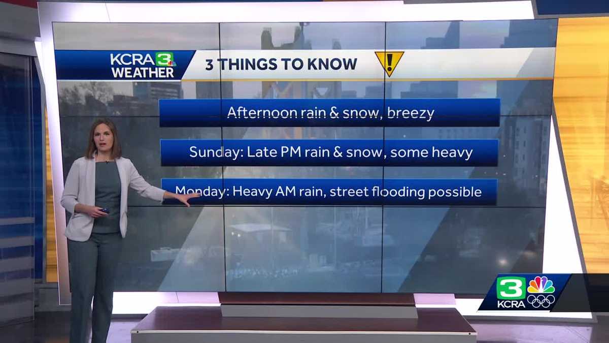
On Saturday, rain and snow showers are likely to arrive in the afternoon hours. The KCRA 3 weather team is calling Saturday an Impact Day because of how the weather could affect travel, especially in the mountains.
Less than a half-inch of rain is expected to fall in the Valley. In the Foothills, anywhere from a half-inch to three-quarters of an inch could fall.
Conditions on Sunday are expected to dry out after the morning hours. Sunday morning will be a good time for travel in the Valley, Foothills and Sierra.
The second round of rain and snow will arrive later Sunday afternoon. Rain could be heavier compared to Saturday and it will last for several hours. This could result in some isolated street flooding. Sunday is now a weather Impact Day because of the evening rain and snow.
The heaviest rain is expected to come through late Sunday night into Monday morning. Some narrow bands of heavy rain are possible during this time. This could result in scattered flooding issues on low-lying streets and some smaller creeks and streams.
Some gusty winds could happen Sunday night and Monday, but Chief Meteorologist Mark Finan said the winds do not appear like they will be strong enough for widespread damage.
Timeline for snow in the Sierra
According to meteorologist Dirk Verdoorn, when the snow does hit the Sierra, it will mostly be at higher elevations.
On Saturday afternoon, snow will begin at 6,000 feet, and that will rise to around 6,700 feet in the evening.

“Then things start to warm up,” “Verdoorn said. By Sunday afternoon, we’re up to around 7,000 feet, and then we see those snow levels start to steadily decrease as we make our way into Monday.”
On Saturday, we are expecting anywhere from 3-6 inches of snow. And on between Sunday evening and Monday morning, Verdoorn said we could see up to a foot of snow.
Get California storm-ready
Follow our KCRA weather team on social media
Watch our forecasts on TV or online
Here’s where to find our latest video forecast. You can also watch a livestream of our latest newscast here. The banner on our website turns red when we’re live.
We’re also streaming on the Very Local app for Roku, Apple TV or Amazon Fire TV.