
A significant storm is impacting New Hampshire on Saturday, with more snow, wintry mix and eventually rain to move through during the day. Roads are slippery in most areas.A winter storm warning is in effect for all of New Hampshire through Saturday evening, except eastern Hillsborough County and Rockingham County, where a winter weather advisory is in effect through midday on Saturday.>> National Weather Service alerts and bulletinsMeanwhile, in areas expected to see the most rain from this system — Rockingham county and eastern Hillsborough county — a flood watch is in effect. PRECIPITATION TYPES & TIMINGLight-to-moderate snow continues early Saturday, with a few inches snow accumulation by the mid-morning in many spots, with a bit more in central and western New Hampshire. >> Interactive Radar Expect the snow to transition to a period of sleet and freezing rain for much of southern New Hampshire later in the morning, with plain rain expected along and near the coast. Heavy snow will continue through most of the day for the Upper Valley, the White Mountains and the Great North Woods.>> See the latest hour-by-hour storm timeline:Travel looks to be slippery all day Saturday in northern and central New Hampshire. Travelers in southern areas will have to contend with slippery roads due to snow and an icy mix in the early part of the day in addition to any ponding from heavy rain late morning and afternoon into the evening.Scattered power outages are also possible. The storm pulls away this evening, with snow, mix and rain tapering off after 9 p.m. PROJECTED SNOW AND RAIN AMOUNTSIn areas where the precipitation stays all snow — the Upper Valley, the White Mountains and the North Country – about 12-18 inches of snow, or more, is expected.Farther south, amounts are more difficult to project because the snow will likely mix with sleet and freezing rain, for a time, from from Claremont to Plymouth and through the Lakes Region. Amounts of 6-12 inches are possible, but those totals could shift a bit depending on how long the wintry mix lasts.About 3-6 inches of snow is expected for Rochester, over to Concord, and down into parts of the Monadnock Region. A coating to perhaps a couple inches is expected in the lower Merrimack Valley, to the Seacoast, and down along the Massachusetts border, but this largely gets washed away by rain later Saturday.Speaking of rain, a period of steady rain and downpours is likely for far southern New Hampshire later today and into this evening. About 1-3 inches of rain could create areas of ponding on roads.LOOKING AHEADAfter the storm moves out, lows will settle in the 20s for many.Sunday will be cloudy but dry with highs in the low 40s. Some sunshine will build back in for Monday, as temperatures stay seasonably cool. Stay tuned to the Storm Watch 9 team forecasts for updates.Be weather-aware! Download the WMUR app for Apple or Android devices and turn on push notifications. You can choose to receive weather alerts for your geolocation and/or up to three ZIP codes. In addition, you can receive word when precipitation is coming to your area.Get storm coverage through the free Very Local app on your smart TV.Follow the Storm Watch 9 team on social media:Mike Haddad: Facebook | XKevin Skarupa: Facebook | XHayley LaPoint: Facebook | XJacqueline Thomas: Facebook | XMatt Hoenig: Facebook | X
A significant storm is impacting New Hampshire on Saturday, with more snow, wintry mix and eventually rain to move through during the day. Roads are slippery in most areas.

A winter storm warning is in effect for all of New Hampshire through Saturday evening, except eastern Hillsborough County and Rockingham County, where a winter weather advisory is in effect through midday on Saturday.
>> National Weather Service alerts and bulletins
Meanwhile, in areas expected to see the most rain from this system — Rockingham county and eastern Hillsborough county — a flood watch is in effect.
PRECIPITATION TYPES & TIMING
Light-to-moderate snow continues early Saturday, with a few inches snow accumulation by the mid-morning in many spots, with a bit more in central and western New Hampshire.
>> Interactive Radar
Expect the snow to transition to a period of sleet and freezing rain for much of southern New Hampshire later in the morning, with plain rain expected along and near the coast.
Heavy snow will continue through most of the day for the Upper Valley, the White Mountains and the Great North Woods.
>> See the latest hour-by-hour storm timeline:
Travel looks to be slippery all day Saturday in northern and central New Hampshire. Travelers in southern areas will have to contend with slippery roads due to snow and an icy mix in the early part of the day in addition to any ponding from heavy rain late morning and afternoon into the evening.
Scattered power outages are also possible.
The storm pulls away this evening, with snow, mix and rain tapering off after 9 p.m.
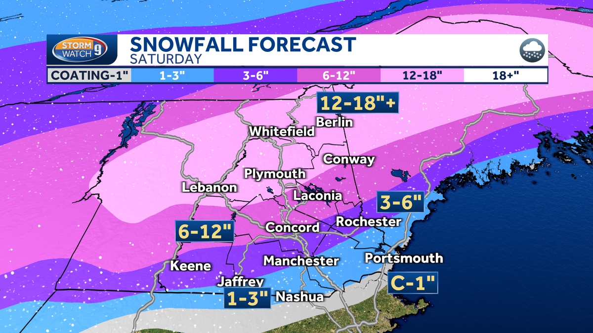
PROJECTED SNOW AND RAIN AMOUNTS
In areas where the precipitation stays all snow — the Upper Valley, the White Mountains and the North Country – about 12-18 inches of snow, or more, is expected.
Farther south, amounts are more difficult to project because the snow will likely mix with sleet and freezing rain, for a time, from from Claremont to Plymouth and through the Lakes Region. Amounts of 6-12 inches are possible, but those totals could shift a bit depending on how long the wintry mix lasts.
About 3-6 inches of snow is expected for Rochester, over to Concord, and down into parts of the Monadnock Region.
A coating to perhaps a couple inches is expected in the lower Merrimack Valley, to the Seacoast, and down along the Massachusetts border, but this largely gets washed away by rain later Saturday.
Speaking of rain, a period of steady rain and downpours is likely for far southern New Hampshire later today and into this evening. About 1-3 inches of rain could create areas of ponding on roads.
LOOKING AHEAD
After the storm moves out, lows will settle in the 20s for many.
Sunday will be cloudy but dry with highs in the low 40s.
Some sunshine will build back in for Monday, as temperatures stay seasonably cool.
Stay tuned to the Storm Watch 9 team forecasts for updates.
Be weather-aware! Download the WMUR app for Apple or Android devices and turn on push notifications. You can choose to receive weather alerts for your geolocation and/or up to three ZIP codes. In addition, you can receive word when precipitation is coming to your area.
Get storm coverage through the free Very Local app on your smart TV.
Follow the Storm Watch 9 team on social media: