
Video above: The latest forecast from WVTM 13 meteorologistsAfter strong storms Tuesday, another powerful storm system brings high wind gusts and heavy rainfall. This time, there is a more substantial threat of severe weather for Central Alabama, including a higher chance of tornadoes. Friday is an Alert Day with a severe weather threat Friday. An Alert Day means there is the possibility of life-threatening weather.>> WVTM 13 ON-THE-GO: Download our app for freeFriday is an ALERT DAY for us again. That means dangerous weather develops over much of the state, but the impacts will be very different from place to place.>> AHEAD OF THE STORM: How to prepare yourself and your homeTimingThere are two factors to “time” out with this round. First, the wind begins to gust over 40 mph between 12 a.m. and 6 a.m. Friday. It increases through the morning, peaking between 50 and 70 mph by early afternoon.The risk of “severe” thunderstorms (large hail, high wind gusts over 60 mph, and tornadoes) runs from around 8 a.m. at the earliest to 4 p.m. at the latest in Central Alabama. The primary window for severe storms in Birmingham, Tuscaloosa, Anniston, Gadsden, Clanton, Cullman, Talladega, and Alexander City runs from around 11 a.m. to 4 p.m.>> CHECK YOUR AREA: WVTM 13 Live Doppler RadarMain threatsThe Storm Prediction Center outlines an “Enhanced Risk” of severe storms for part of Alabama on Friday. Whether you are inside that outline or not, pay close attention to the weather on Friday.>> BE AWARE: Current weather alerts in your areaThe northern extent of the threat is still a little uncertain, so stay with WVTM 13 as we track this system. We will update you on the who, what, when and where of this system as it develops.Areas south of Interstate 20 and east of Interstate 65 have the highest tornado threat, but everyone should be prepared.>> DURING SEVERE WEATHER: 5 ways to stay safeThis round most likely comes as a squall line with damaging thunderstorm wind gusts. A few storms may develop ahead of the squall line and will have a higher threat of producing a tornado, perhaps even a strong one.This round most likely comes as a squall line with damaging thunderstorm wind gusts. A few storms may develop ahead of the squall line and will have a higher threat of producing a tornado, perhaps even a strong one.>> SHARE WITH US: Upload your photos and videos via uLocalAfter the stormFriday’s storm system is the first in a series of cold fronts driving Arctic air across the nation. Expect a steep temperature drop for Saturday: highs only in the 30s and 40s with a morning low in the mid-20s.Sunday also looks colder than normal, even as another, more intense Arctic front approaches from the northwest.>> FOLLOW US ON SOCIAL: Facebook | Twitter | Instagram | YouTube You may have heard the rumors of winter storms next week, and those rumors have some merit. Officially, we are not forecasting a significant threat of snow or ice for the Birmingham area – yet.There is a chance that as some brutally cold air slides in Monday that enough moisture is left for a quick round of sleet, snow, and freezing rain through Central Alabama. Temperatures then plunge below freezing for several straight days next week.The coming cold will rival Christmas 2022 and December 1989, with low temperatures near or below 10 degrees in the Tennessee Valley next week. Birmingham could drop as low as 10-15 degrees several mornings next week as well.Stay weather awareFor the latest weather coverage for your area, click here. And stay updated with alerts in the WVTM 13 app. You can download it here.For the latest Birmingham weather information and central Alabama’s certified most accurate forecast, watch WVTM 13 News.Don’t forget to follow us on Facebook, Twitter and Instagram.>> SHARE WITH US: Upload your photos and videos via uLocal
Video above: The latest forecast from WVTM 13 meteorologists
After strong storms Tuesday, another powerful storm system brings high wind gusts and heavy rainfall. This time, there is a more substantial threat of severe weather for Central Alabama, including a higher chance of tornadoes.
Friday is an Alert Day with a severe weather threat Friday. An Alert Day means there is the possibility of life-threatening weather.
>> WVTM 13 ON-THE-GO: Download our app for free
This content is imported from Facebook.
You may be able to find the same content in another format, or you may be able to find more information, at their web site.
Friday is an ALERT DAY for us again. That means dangerous weather develops over much of the state, but the impacts will be very different from place to place.
>> AHEAD OF THE STORM: How to prepare yourself and your home
Timing
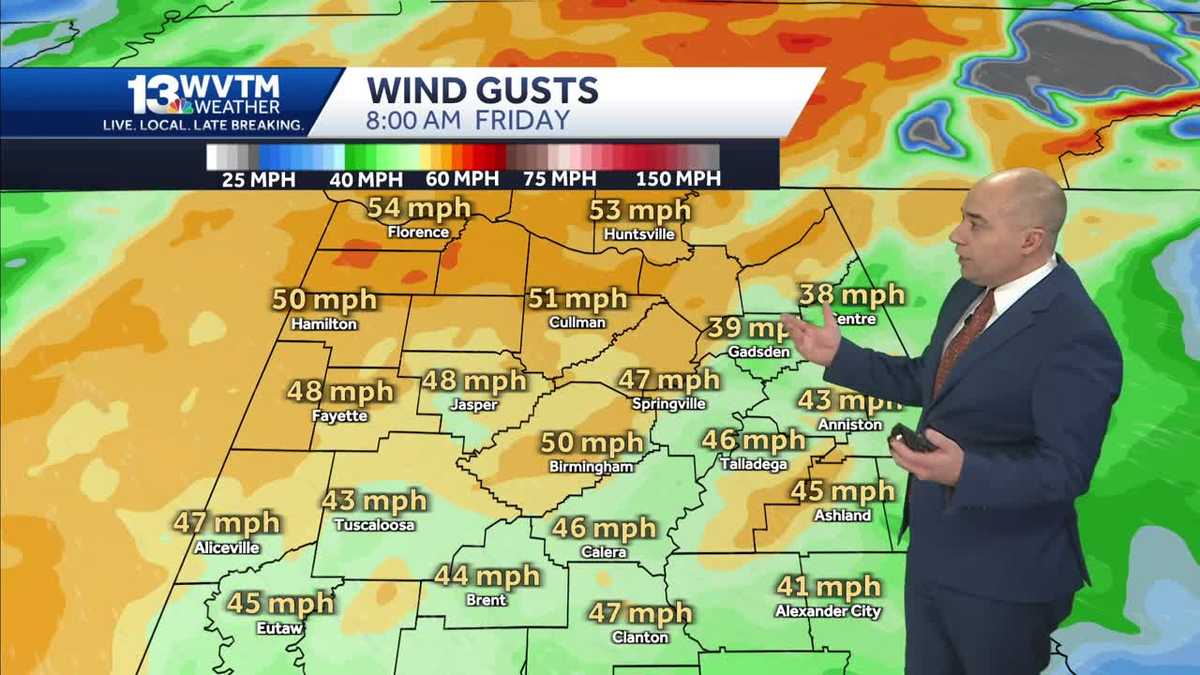
There are two factors to “time” out with this round. First, the wind begins to gust over 40 mph between 12 a.m. and 6 a.m. Friday. It increases through the morning, peaking between 50 and 70 mph by early afternoon.
The risk of “severe” thunderstorms (large hail, high wind gusts over 60 mph, and tornadoes) runs from around 8 a.m. at the earliest to 4 p.m. at the latest in Central Alabama. The primary window for severe storms in Birmingham, Tuscaloosa, Anniston, Gadsden, Clanton, Cullman, Talladega, and Alexander City runs from around 11 a.m. to 4 p.m.

>> CHECK YOUR AREA: WVTM 13 Live Doppler Radar
Main threats
The Storm Prediction Center outlines an “Enhanced Risk” of severe storms for part of Alabama on Friday. Whether you are inside that outline or not, pay close attention to the weather on Friday.

>> BE AWARE: Current weather alerts in your area
The northern extent of the threat is still a little uncertain, so stay with WVTM 13 as we track this system. We will update you on the who, what, when and where of this system as it develops.
Areas south of Interstate 20 and east of Interstate 65 have the highest tornado threat, but everyone should be prepared.
>> DURING SEVERE WEATHER: 5 ways to stay safe
This round most likely comes as a squall line with damaging thunderstorm wind gusts. A few storms may develop ahead of the squall line and will have a higher threat of producing a tornado, perhaps even a strong one.
This round most likely comes as a squall line with damaging thunderstorm wind gusts. A few storms may develop ahead of the squall line and will have a higher threat of producing a tornado, perhaps even a strong one.
>> SHARE WITH US: Upload your photos and videos via uLocal
After the storm
Friday’s storm system is the first in a series of cold fronts driving Arctic air across the nation. Expect a steep temperature drop for Saturday: highs only in the 30s and 40s with a morning low in the mid-20s.
Sunday also looks colder than normal, even as another, more intense Arctic front approaches from the northwest.
>> FOLLOW US ON SOCIAL: Facebook | Twitter | Instagram | YouTube
You may have heard the rumors of winter storms next week, and those rumors have some merit. Officially, we are not forecasting a significant threat of snow or ice for the Birmingham area – yet.

There is a chance that as some brutally cold air slides in Monday that enough moisture is left for a quick round of sleet, snow, and freezing rain through Central Alabama. Temperatures then plunge below freezing for several straight days next week.

The coming cold will rival Christmas 2022 and December 1989, with low temperatures near or below 10 degrees in the Tennessee Valley next week. Birmingham could drop as low as 10-15 degrees several mornings next week as well.
Stay weather aware
For the latest weather coverage for your area, click here. And stay updated with alerts in the WVTM 13 app. You can download it here.
For the latest Birmingham weather information and central Alabama’s certified most accurate forecast, watch WVTM 13 News.
Don’t forget to follow us on Facebook, Twitter and Instagram.
>> SHARE WITH US: Upload your photos and videos via uLocal