
A low pressure has strengthened into Tropical Storm Ophelia, and it will bring heavy rain and strong winds to Maryland.Ophelia is expected to bring tropical-storm-force winds, storm surge, heavy rain and high surf to Maryland.Strengthening is expected over the next couple days as the tropical storm approaches the North Carolina coast Friday night.NATIONAL HURRICANE CENTER ADVISORY — 2 p.m. FridayTropical Storm OpheliaLocation: 32.7N 76.0W, about 150 miles SE of Cape Fear, NCMaximum sustained winds: 60 mphMovement: NNW at 12 mphMinimum central pressure: 992 mbHURRICANE PREPARATION: How to prepare for hurricanesHere are the possibilities:Storm surge of 1-3 feetAbout 2-4 inches of rainFloodingPeak wind gusts of 50-55 mphSTORM TRACKThe storm’s center will approach the coast of North Carolina through Friday night, and then move across eastern North Carolina, southeastern Virginia, and the Delmarva Peninsula Saturday and Sunday.As of 2 p.m. Friday, tropical-storm-force winds extended outward up to 275 miles from the center.SEVERE WEATHER ALERTSThe National Weather Service issued a Storm Surge Warning for the Chesapeake Bay south of Colonial Beach, Virginia.A Tropical Storm Warning has been extended northward into the Chesapeake Bay to North Beach, and into the Tidal Potomac to Cobb Island. This includes Calvert and St. Mary’s counties in Southern Maryland and Dorchester, Somerset, Wicomico and Worcester counties.A Wind Advisory is now in effect from 8 a.m. to 8 p.m. for parts of Central Maryland along the Interstate 95 corridor. Northeast winds 20-30 mph with gusts up to 45 mph expected. Gusts up to 50 mph are likely along the immediate shore of the Chesapeake Bay and Tidal Potomac. App users tap here for interactive weather linksWhat this means for Maryland, and whenFRIDAY — Calm before the stormOther than a breeze picking up, clouds will increase and weather conditions will remain quiet and dry for most of Friday. Conditions will deteriorate Friday night as rain moves in from the southeast.Dalencia explains: Storm = not the best beach weekendSATURDAY — Get ready for steady rainCome Saturday, rain will be heavy at times and could lead to localized flooding in low-lying, poor drainage areas. About 2-4 inches of rain will be possible and locally high amounts can’t be ruled out, especially closer to the coast.A few tornadoes will also be possible on Saturday, with areas south and east of metropolitan Baltimore at higher risk. Tropical-storm-force winds will be possible across parts of Southern Maryland and the Lower Eastern Shore with peak winds 35-45 mph and gusts to 50 mph mainly Saturday afternoon and Saturday evening.| RELATED: Your rights if an airline cancels your flightLocalized storm surge of 1-3 feet above ground will be possible beginning early Saturday morning through Sunday morning for locations along the western shore of the Chesapeake Bay as well as the shore of the tidal Potomac River. Highest water levels are expected around times of high tide Saturday and Saturday night.Residents around the the lower Chesapeake Bay should watch the weather forecast closely as the storm develops.SUNDAY — Storm moves outNEW as of Friday afternoon: Sunday’s forecast is starting to look at little more promising with a change to the forecast that shows the system appearing to move faster out of Maryland, which would be good news for the Ravens game.WEEKEND EVENTS CANCELEDSATURDAY events canceled:The Annapolis Kunta Kinte FestivalThe Big Bike Build fundraiser at Stevenson UniversityThe Harford County Wine FestivalThe Susquehanna River Running FestivalDownload the WBAL-TV app NOW and turn on push alerts to be aware of alerts, listen to NOAA Weather radio, and watch WBAL-TV 11 when impending severe weather develops.Follow: @wbaltv11 | @TTasselWBAL | @AvaWBAL | @TonyPannWBAL | @DalenciaWBAL | @ChelseaWeatherALERTS: Severe weather alerts from the WBAL-TV app: step-by-step guideCLOSINGS: See if schools, businesses or organizations have closed or delayedRADAR: Track the storm on WBAL-TV’s interactive radarROADS: Check for crashes and backups with our interactive traffic mapTORNADO SURVIVAL: 5 things you need to do nowTROPICAL ATLANTIC STORM PATH MARYLAND’S WEATHER RADARMARYLAND FLOOD ALERTSMARYLAND’S 7-DAY FORECASTWBAL-TV 11’s OCEAN CITY WEBCAMWBAL-TV 11’s ANNAPOLIS WEBCAM WBAL-TV 11 Maryland Weather RadarApp users tap here for radar.Stay informed, understand the terminologyTropical storms and hurricanes each have two descriptors, a watch and a warning. Watches and warnings are issued in advance of the onset of tropical storm force winds (39-73 mph).WATCH: This means tropical storm or hurricane conditions are possible in the “watch area.” A watch is issued up to 48 hours in advance of the onset of tropical storm-force winds.WARNING: This means tropical storm or hurricane conditions are expected in the “warning area.” A warning is issued up to 36 hours in advance of the onset of tropical storm-force winds.Tropical Depression: A tropical cyclone with maximum sustained surface winds of 38 mph or less.Tropical Storm: A tropical cyclone that has maximum sustained surface winds ranging from 39-73 mph.Category 1 hurricane: Sustained winds of 74-95 mph — very dangerous winds will produce some damage.Category 2 hurricane: 96-110 mph winds — Extremely dangerous winds will cause extensive damage. Near-total power loss is expected with outages that could last from several days to weeks.Category 3 major hurricane: 111-129 mph winds — Devastating damage will occur. Electricity and water will be unavailable for several days to weeks after the storm passes.Category 4 major hurricane: 130-156 mph winds — Catastrophic damage will occur. Power outages will last weeks to possibly months. Most of the area will be uninhabitable for weeks or months.Category 5 major hurricane: 157 mph winds or higher — Catastrophic damage will occur. A high percentage of framed homes will be destroyed, with total roof failure and wall collapse. Fallen trees and power poles will isolate residential areas. Power outages will last for weeks to possibly months. Most of the area will be uninhabitable for weeks or months.Hurricane season can be a daunting time of year if you live in a hurricane-prone region like the Mid-Atlantic. A single hurricane making landfall can leave a trail of devastation, especially in the most flood-prone areas of Baltimore.While it’s rare for an actual hurricane (that is, a storm with sustained winds above 74 mph) to make landfall in Baltimore, it’s not uncommon for the remnants of one to bring storm surges, heavy rainfall and high winds, which can be plenty destructive. (The most recent hurricanes to cause major damage in Maryland were Irene in 2011 and Isabel in 2003.) Low-lying areas of the city — such as Mount Washington, Clipper Mill and Fells Point — are particularly vulnerable to flooding.How to prepare for hurricanesHere are some of the most important hurricane preparedness recommendations for homeowners in Florida and in other hurricane-prone states.Know your zoneThe Maryland Department of Emergency Management makes it easy to know if you need to evacuate during a hurricane or tropical storm. Visit KnowYourZoneMD.com and enter your address to find out what evacuation zone you live in (they’re color-coded and labeled either A, B or C).During severe weather, you’ll then receive instructions on whether to evacuate or shelter in place. The highest risk areas will be evacuated first, followed by lower risk zones, if needed. (Note that even if you don’t live in one of the three official zones, you might still need to evacuate, depending on the weather situation.)Know your evacuation routeBefore or during a hurricane, you might be ordered to evacuate your home. Find out the locations of your closest shelters and figure out how you will get to them. While Baltimore does not designate specific evacuation routes, you can plan ahead by looking up alternative driving routes. If possible, keep a map in your vehicle so you can redirect yourself on the fly, if necessary.Store and collect suppliesMake sure you have enough food, water and medical supplies for each family member to last at least two or three days. Your hurricane supply kit should also be stocked with a radio, extra batteries, a flashlight, space blankets and important documents.Don’t forget your petsYour pets are important members of the family, and they need to be taken care of during an emergency. Learn which shelters do and don’t accept pets. Or, you can consider a pet-friendly hotel that’s outside the evacuation zone.Download the FEMA mobile appFEMA’s mobile app has many disaster resources, including safety tips and weather alerts. It also has a checklist of emergency supplies and shelters and will keep you updated with real-time alerts from the National Weather Service.Protect your homeOnce you’ve made your emergency plan and assembled your emergency kit, it’s time to prepare your home. While this list can feel overwhelming, it doesn’t have to be done all at once. Instead, start working your way through the list now, and check off items once completed.Landscaping — Replace gravel or stone garden beds with lighter material that will not damage your property in high winds.Trees and shrubs — Remove any weak, dying, or damaged trees and branches which could break off in high winds and crash into your house.Windows — Consider installing storm shutters to prevent window glass from breaking. Plywood sheets can also be used in a pinch.Doors — Think about swapping your current doors for hurricane-proof doors with three hinges and a deadbolt. Ideally, glass sliding doors should be made of tempered glass and protected by storm shutters or plywood.Garage doors — Ensure your garage or roller doors are in good working condition and locked securely.Vents and wall openings — Fill any vents or exterior holes with high-quality urethane-based caulk to prevent water penetration.Boats — If you keep a boat in your yard, anchor your boat securely to a tree or the ground before the storm arrives.Insurance coverageIf you live in an area that experiences hurricanes and tropical storms, it’s important to have the right insurance coverage. Tap here to see some types of insurance that will cover your home and your personal belongings in the event of a major storm.
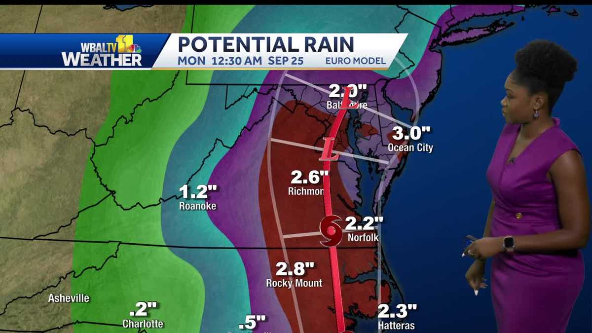
A low pressure has strengthened into Tropical Storm Ophelia, and it will bring heavy rain and strong winds to Maryland.
Ophelia is expected to bring tropical-storm-force winds, storm surge, heavy rain and high surf to Maryland.
Strengthening is expected over the next couple days as the tropical storm approaches the North Carolina coast Friday night.
NATIONAL HURRICANE CENTER ADVISORY — 2 p.m. Friday
- Tropical Storm Ophelia
- Location: 32.7N 76.0W, about 150 miles SE of Cape Fear, NC
- Maximum sustained winds: 60 mph
- Movement: NNW at 12 mph
- Minimum central pressure: 992 mb
HURRICANE PREPARATION: How to prepare for hurricanes
Here are the possibilities:
- Storm surge of 1-3 feet
- About 2-4 inches of rain
- Flooding
- Peak wind gusts of 50-55 mph
STORM TRACK
The storm’s center will approach the coast of North Carolina through Friday night, and then move across eastern North Carolina, southeastern Virginia, and the Delmarva Peninsula Saturday and Sunday.
As of 2 p.m. Friday, tropical-storm-force winds extended outward up to 275 miles from the center.
This content is imported from YouTube.
You may be able to find the same content in another format, or you may be able to find more information, at their web site.
SEVERE WEATHER ALERTS
The National Weather Service issued a Storm Surge Warning for the Chesapeake Bay south of Colonial Beach, Virginia.
A Tropical Storm Warning has been extended northward into the Chesapeake Bay to North Beach, and into the Tidal Potomac to Cobb Island. This includes Calvert and St. Mary’s counties in Southern Maryland and Dorchester, Somerset, Wicomico and Worcester counties.
A Wind Advisory is now in effect from 8 a.m. to 8 p.m. for parts of Central Maryland along the Interstate 95 corridor. Northeast winds 20-30 mph with gusts up to 45 mph expected. Gusts up to 50 mph are likely along the immediate shore of the Chesapeake Bay and Tidal Potomac.
App users tap here for interactive weather links
What this means for Maryland, and when
FRIDAY — Calm before the storm
Other than a breeze picking up, clouds will increase and weather conditions will remain quiet and dry for most of Friday. Conditions will deteriorate Friday night as rain moves in from the southeast.
Dalencia explains: Storm = not the best beach weekend
SATURDAY — Get ready for steady rain
Come Saturday, rain will be heavy at times and could lead to localized flooding in low-lying, poor drainage areas. About 2-4 inches of rain will be possible and locally high amounts can’t be ruled out, especially closer to the coast.
A few tornadoes will also be possible on Saturday, with areas south and east of metropolitan Baltimore at higher risk. Tropical-storm-force winds will be possible across parts of Southern Maryland and the Lower Eastern Shore with peak winds 35-45 mph and gusts to 50 mph mainly Saturday afternoon and Saturday evening.
| RELATED: Your rights if an airline cancels your flight
This content is imported from Twitter.
You may be able to find the same content in another format, or you may be able to find more information, at their web site.
Localized storm surge of 1-3 feet above ground will be possible beginning early Saturday morning through Sunday morning for locations along the western shore of the Chesapeake Bay as well as the shore of the tidal Potomac River. Highest water levels are expected around times of high tide Saturday and Saturday night.
Residents around the the lower Chesapeake Bay should watch the weather forecast closely as the storm develops.
SUNDAY — Storm moves out
NEW as of Friday afternoon: Sunday’s forecast is starting to look at little more promising with a change to the forecast that shows the system appearing to move faster out of Maryland, which would be good news for the Ravens game.
WEEKEND EVENTS CANCELED
SATURDAY events canceled:
- The Annapolis Kunta Kinte Festival
- The Big Bike Build fundraiser at Stevenson University
- The Harford County Wine Festival
- The Susquehanna River Running Festival
Download the WBAL-TV app NOW and turn on push alerts to be aware of alerts, listen to NOAA Weather radio, and watch WBAL-TV 11 when impending severe weather develops.
Follow: @wbaltv11 | @TTasselWBAL | @AvaWBAL | @TonyPannWBAL | @DalenciaWBAL | @ChelseaWeather
TROPICAL ATLANTIC STORM PATH
MARYLAND’S WEATHER RADAR

MARYLAND FLOOD ALERTS

MARYLAND’S 7-DAY FORECAST
WBAL-TV 11’s OCEAN CITY WEBCAM
WBAL-TV 11’s ANNAPOLIS WEBCAM
WBAL-TV 11 Maryland Weather Radar
App users tap here for radar.
Stay informed, understand the terminology
Tropical storms and hurricanes each have two descriptors, a watch and a warning. Watches and warnings are issued in advance of the onset of tropical storm force winds (39-73 mph).
WATCH: This means tropical storm or hurricane conditions are possible in the “watch area.” A watch is issued up to 48 hours in advance of the onset of tropical storm-force winds.
WARNING: This means tropical storm or hurricane conditions are expected in the “warning area.” A warning is issued up to 36 hours in advance of the onset of tropical storm-force winds.
Tropical Depression: A tropical cyclone with maximum sustained surface winds of 38 mph or less.
Tropical Storm: A tropical cyclone that has maximum sustained surface winds ranging from 39-73 mph.
Category 1 hurricane: Sustained winds of 74-95 mph — very dangerous winds will produce some damage.
Category 2 hurricane: 96-110 mph winds — Extremely dangerous winds will cause extensive damage. Near-total power loss is expected with outages that could last from several days to weeks.
This content is imported from Twitter.
You may be able to find the same content in another format, or you may be able to find more information, at their web site.
Category 3 major hurricane: 111-129 mph winds — Devastating damage will occur. Electricity and water will be unavailable for several days to weeks after the storm passes.
Category 4 major hurricane: 130-156 mph winds — Catastrophic damage will occur. Power outages will last weeks to possibly months. Most of the area will be uninhabitable for weeks or months.
Category 5 major hurricane: 157 mph winds or higher — Catastrophic damage will occur. A high percentage of framed homes will be destroyed, with total roof failure and wall collapse. Fallen trees and power poles will isolate residential areas. Power outages will last for weeks to possibly months. Most of the area will be uninhabitable for weeks or months.

Hurricane season can be a daunting time of year if you live in a hurricane-prone region like the Mid-Atlantic. A single hurricane making landfall can leave a trail of devastation, especially in the most flood-prone areas of Baltimore.
While it’s rare for an actual hurricane (that is, a storm with sustained winds above 74 mph) to make landfall in Baltimore, it’s not uncommon for the remnants of one to bring storm surges, heavy rainfall and high winds, which can be plenty destructive. (The most recent hurricanes to cause major damage in Maryland were Irene in 2011 and Isabel in 2003.) Low-lying areas of the city — such as Mount Washington, Clipper Mill and Fells Point — are particularly vulnerable to flooding.
How to prepare for hurricanes
Here are some of the most important hurricane preparedness recommendations for homeowners in Florida and in other hurricane-prone states.
Know your zone
The Maryland Department of Emergency Management makes it easy to know if you need to evacuate during a hurricane or tropical storm. Visit KnowYourZoneMD.com and enter your address to find out what evacuation zone you live in (they’re color-coded and labeled either A, B or C).

During severe weather, you’ll then receive instructions on whether to evacuate or shelter in place. The highest risk areas will be evacuated first, followed by lower risk zones, if needed. (Note that even if you don’t live in one of the three official zones, you might still need to evacuate, depending on the weather situation.)
Know your evacuation route
Before or during a hurricane, you might be ordered to evacuate your home. Find out the locations of your closest shelters and figure out how you will get to them. While Baltimore does not designate specific evacuation routes, you can plan ahead by looking up alternative driving routes. If possible, keep a map in your vehicle so you can redirect yourself on the fly, if necessary.
Store and collect supplies
Make sure you have enough food, water and medical supplies for each family member to last at least two or three days. Your hurricane supply kit should also be stocked with a radio, extra batteries, a flashlight, space blankets and important documents.
Don’t forget your pets
Your pets are important members of the family, and they need to be taken care of during an emergency. Learn which shelters do and don’t accept pets. Or, you can consider a pet-friendly hotel that’s outside the evacuation zone.
Download the FEMA mobile app
FEMA’s mobile app has many disaster resources, including safety tips and weather alerts. It also has a checklist of emergency supplies and shelters and will keep you updated with real-time alerts from the National Weather Service.
Protect your home
Once you’ve made your emergency plan and assembled your emergency kit, it’s time to prepare your home. While this list can feel overwhelming, it doesn’t have to be done all at once. Instead, start working your way through the list now, and check off items once completed.
- Landscaping — Replace gravel or stone garden beds with lighter material that will not damage your property in high winds.
- Trees and shrubs — Remove any weak, dying, or damaged trees and branches which could break off in high winds and crash into your house.
- Windows — Consider installing storm shutters to prevent window glass from breaking. Plywood sheets can also be used in a pinch.
- Doors — Think about swapping your current doors for hurricane-proof doors with three hinges and a deadbolt. Ideally, glass sliding doors should be made of tempered glass and protected by storm shutters or plywood.
- Garage doors — Ensure your garage or roller doors are in good working condition and locked securely.
- Vents and wall openings — Fill any vents or exterior holes with high-quality urethane-based caulk to prevent water penetration.
- Boats — If you keep a boat in your yard, anchor your boat securely to a tree or the ground before the storm arrives.
Insurance coverage
If you live in an area that experiences hurricanes and tropical storms, it’s important to have the right insurance coverage. Tap here to see some types of insurance that will cover your home and your personal belongings in the event of a major storm.